
Image 1 of 4
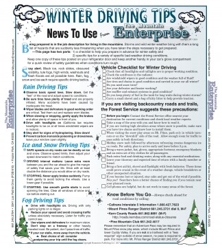
Double click on the image for a full-size printable version of Winter Driving Tips.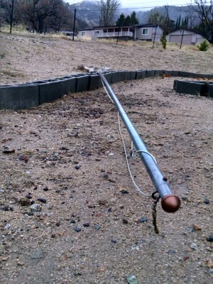
Image 2 of 4
Jim Stoughton of Los Padres Estates in Lebec used 21.5 pounds of Portland cement three feet in the ground to anchor this flagpole. But it was laid flat. Stoughton said it is 1/4 inch zinc plated hollow steel fence pole with no flag, that bent over at the ground in a blast of wind. He says next he'll go tarp the roof that had shingles blown off.
Image 3 of 4
Jeff Zimmerman's Neenach measurement is showing two inches of rain so far today, Tuesday, Jan. 9, 2018.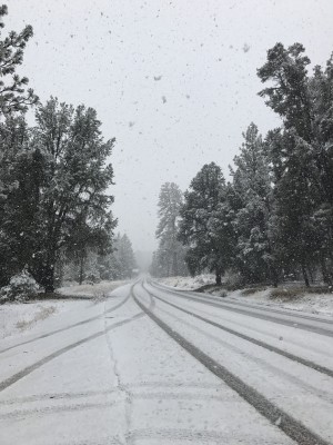
Image 4 of 4
Dionne Bolton took this photo Tuesday afternoon on Mil Potrero Highway west of Pine Mountain Club as rain turned to snow and covered the roads.
UPDATE – Frazier Park, CA (Wednesday, Jan. 10, 2018 at 2:25 p.m.)—The National Weather reports that slightly higher temperatures (low 60s) and sunshine are in store for the coming week.
UPDATE – Frazier Park, CA (Tuesday, Jan. 9, 2018 at 8:10 p.m.)—The National Weather Service predicts more snow and rain are likely this evening, with clearing on Wednesday. Please drive slowly this evening. Black ice is possible. Be ready to put on chains and spiders.
UPDATE – Pine Mountain Club, CA (Tuesday, Jan. 9, 2018 at 4:15 p.m.)—The National Weather Service is predicting snow showers in PMC until 11 p.m. Mil Potrero Highway is open now, but conditions could change.
Storm Note—Shocking reports are now in that at least 13 people have died in this rainstorm near the coast from flooding and mudflows, many in Montecito, Santa Barbara County. Damage to the hillsides from the Thomas fire set the conditions for slides, flooding and debris flow. Highway 101 is flooded and will remain closed north of SR 126 through Santa Barbara County, likely for several days, Caltrans officials report, as mud and debris are removed and infrastructure damage is investigated.
UPDATE – Pine Mountain Club, CA (Tuesday, Jan. 9, 2018 at 1:55 p.m.)—Mil Potrero Highway is now open in both directions according to CHP Fort Tejon Office.
UPDATE – Pine Mountain Club, CA (Tuesday, Jan. 9, 2018 at 1:15 p.m.)—Gorman School began letting students out as of 1 p.m. El Tejon Unified School District is keeping its regular schedule to give roads crews time to clear Mil Potrero Highway before school buses are on the road.
UPDATE – Pine Mountain Club, CA (Tuesday, Jan. 9, 2018 at 12:54 p.m.)—Mil Potrero Highway is closed to traffic in or out of PMC. Westbound is closed at the Y. CHP is recommending that no one attempt to leave PMC on Mil Potrero Highway until Kern County Roads Department is able to clean up a mudslide.
UPDATE – Pine Mountain Club, CA (Tuesday, Jan. 9, 2018 at 12:25 p.m.)—It is white-out conditions now in PMC, with wet snow sticking to windshields, roofs, trees and roads.
UPDATE – Pine Mountain Club, CA (Tuesday, Jan. 9, 2018 at 12:01 p.m.)— Fluffy, snowglobe snow clusters are now starting to stick to windshields, roofs and decks. It is likely the roads will start to see accumulation soon. Have those chains ready. Drive very slowly, please. Be safe. See the updated NWS forecast below.
Storm UPDATE-Note: On the coast, it is reported that flooding and mudslides in Montecito have resulted in five fatalities where homes have been destroyed. As reported earlier, the 101 NB at SR 126 through Ventura County has been closed.
UPDATE – Pine Mountain Club, CA (Tuesday, Jan. 9, 2018 at 10:56 a.m.)— Snow is blowing in, horizontally, with large, wet flakes that are likely to stick if this continues. The temperature does not seem to be low enough yet for that to happen though.
UPDATE – Frazier Park, CA (Tuesday, Jan. 9, 2018 at 10:15 a.m.)—Now another round of light snow that is not sticking on the roads yet has pattered through.
Mostly clear, with a low around 35. Northeast wind 5 to 10 mph.
UPDATE – Frazier Park, CA (Tuesday, Jan. 9, 2018 at 9:30 a.m.)—It seems the 85 mph gusts did come through the Grapevine region. Jim Stoughton of Los Padres Estates said his 20 foot flagpole was blown down, along with shingles from his roof. Jeff Zimmerman reports Neenach received two inches (2″) of rain last night. Oh, yes, and keep sending those perfect rainbow photos.
UPDATE – Frazier Park, CA (Tuesday, Jan. 9, 2018 at 7:50 a.m.)—Ahead of schedule, snow is showing up on the hillsides west of the Pine Mountain community, with rain hitting the ground with the consistency of a slushy. See the National Weather Service forecast, below, and remember to have those chains ready in your car. Drive slowly.
UPDATE – Frazier Park, CA (Tuesday, Jan. 9, 2018 at 6 a.m.)— Gentle rain of yesterday and last night of about 1 inch is due to change into snow showers between 10 a.m. and 4 p.m. the National Weather Service reports. Be sure you have your chains in the car and are ready to use them. Drive s-l-o-w-l-y. Stay safe.
Mostly clear, with a low around 27. Blustery, with a north northeast wind 15 to 20 mph.
UPDATE – Frazier Park, CA (Tuesday, Jan. 9, 2018 at 4 a.m.)—Tuesday morning at 4 a.m. the steady rain continues, with intermittent gusty winds, but temperatures are above freezing and rainfall has remained gentle, with 1.01 inch falling at 6,000 feet in the Pine Mountain Community through Monday and Monday night.
Roads are clear and passable but drive slowly and carefully. Watch for rocks and debris in the roads. Leave plenty of space between yourself and other vehicles. Leave plenty of time to get to your destination so you can be safe.
UPDATE – Frazier Park, CA (Monday, Jan. 8, 2018 at 1 p.m.)—Rain has been falling since about sunrise Monday, off and on, with occasional gusty winds. As of this hour, 0.25 inches of rain have fallen at 6,000 feet in the Pine Mountain community, with similar rainfall elsewhere. Higher winds and snow are expected on Tuesday morning.
Put your traction devices in your car and be prepared to use them. Drive slowly and carefully. Beware of black ice conditions that cannot be detected until it is too late. See the week’s weather forecast below. Drive slowly and carefully. Keep winter driving tips (right) in the glove compartment for quick review.
Frazier Park, CA (Sunday, Jan. 7, 2018 at 1 p.m.)—National Weather Service reports that heavy rain and gusty winds will develop over much of central and southern California by Monday at 4 a.m. In our Mountain Communities, that may be followed Monday night with extremely high wind gusts, up to 85 mph, with snow expected Tuesday. Put your traction devices in your car and be prepared to use them.
Here is the NWS forecast for the Lebec, Frazier Mountain through Pine Mountain community region:
This is part of the January 5, 2018 online edition of The Mountain Enterprise.
Have an opinion on this matter? We'd like to hear from you.