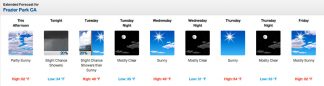
Double click the image to view a larger version of the forecast for Frazier Park from National Weather Service.
FRAZIER PARK, CA (MONDAY, Dec. 10, 2018 at 2 p.m.)—Here’s the National Weather Service forecast for the week.
Detailed Forecast
Monday
Partly sunny, with a high near 52. East wind around 5 mph.
Monday Night
A 20 percent chance of showers. Mostly cloudy, with a low around 34. Northwest wind 5 to 10 mph.
Tuesday
A 20 percent chance of showers before 10am. Sunny, with a high near 48. North northwest wind around 10 mph.
Tuesday Night
Mostly clear, with a low around 35. North northwest wind 10 to 15 mph.
Wednesday
Sunny, with a high near 49. South southeast wind around 15 mph becoming north northwest in the morning. Winds could gust as high as 20 mph.
Wednesday Night
Mostly clear, with a low around 31. Northeast wind around 10 mph, with gusts as high as 15 mph.
Thursday
Sunny, with a high near 54. East wind around 15 mph.
Thursday Night
Mostly clear, with a low around 33. East southeast wind around 15 mph.
Friday
Mostly sunny, with a high near 52. East wind 10 to 15 mph.
Friday Night
Partly cloudy, with a low around 31. Northwest wind around 10 mph.
Saturday
Mostly sunny, with a high near 50. Northeast wind 5 to 10 mph, with gusts as high as 15 mph.
Saturday Night
Mostly cloudy, with a low around 32. Light south wind increasing to 5 to 10 mph in the evening. Winds could gust as high as 15 mph.
Sunday
A 20 percent chance of showers. Mostly cloudy, with a high near 50. South wind 10 to 15 mph.
FRAZIER PARK, CA (THURSDAY, Dec. 6, 2018 at 11 a.m.)—Here’s the National Weather Service forecast for the rest of the week.
Thursday, DECEMBER 6, 2018 –Today
Snow showers. Mostly cloudy, with a temperature falling to around 37 by 5pm. Breezy, with an east northeast wind 20 to 25 mph, with gusts as high as 35 mph. Chance of precipitation is 60%. Little or no snow accumulation expected.
Sunny, with a high near 48. North wind around 15 mph.
FRAZIER PARK, CA (THURSDAY, Dec.6, 2018 at 7:51 a.m.)—Snow is falling in Frazier Park and rain is falling in Lebec. Light snow has been reported on Interstate 5 over the summit.FRAZIER PARK, CA (Wednesday, Dec.5, 2018 at 8:20 a.m.)—Snowflakes are falling in Frazier Park as the National Weather Service has forecast rain today. There are no reports of road closures at this time.
UPDATE–Lebec, Frazier Park, Lake of the Woods, Cuddy Valley, Lockwood Valley, Pine Mountain Club, Piñon Pines (Sunday, Dec.2, 2018 at 3:30 p.m.)— See Breaking News on this page about accident on Mil Potrero Highway and major delays for about 100 travelers Sunday afternoon.
UPDATE–Lebec, Frazier Park, Lake of the Woods, Cuddy Valley, Lockwood Valley, Pine Mountain Club, Piñon Pines (Sunday, Dec.2, 2018 at 11:08 a.m.)—Snow enough to give us all that pre-season Christmas spirit fell yesterday, but gravel is down and roads are open. Watch for black ice on mountain roads. It is time to check our windshield wipers and traction devices. For the rest of the winter we should all be traveling with chains or spike spiders in our vehicles…yes, even those with all-wheel and four-wheel drive. It is a beautiful mountain day! Enjoy, Scroll down to see the National Weather Service forecast.
UPDATE–Lebec, Frazier Park, Lake of the Woods, Cuddy Valley, Lockwood Valley, Pine Mountain Club, Piñon Pines (Saturday, Dec. 1, 2018 at 3:08 p.m.)—Skies are getting a little darker by 3 p.m., but the fun is still hopping at Holiday Faire and Santa is still taking photos for your Christmas cards! Gifts galore, and good food too! Come on down to Mt. Pinos Way in Frazier Park (the main drag). Put on that cozy coat and muffler and come enjoy the parade this afternoon. Scroll down to see the National Weather Service forecast for the week ahead.
UPDATE–Lebec, Frazier Park, Lake of the Woods, Cuddy Valley, Lockwood Valley, Pine Mountain Club, Piñon Pines (Saturday, Dec. 1, 2018 at 1:55 p.m.)—Holiday Faire is lively, come down to share in the fun. Bundle up. It is a lot like winter. There are some clouds on the horizon, but the fun is still flowing. No rain yet.
UPDATE–Lebec, Frazier Park, Lake of the Woods, Cuddy Valley, Lockwood Valley, Pine Mountain Club, Piñon Pines (Saturday, Dec. 1, 2018 at 12:10 p.m.)—Holiday Faire weather is crisp and bright. Festivities began at noon. There are crafts vendors, all kinds of gift-buying opportunities, music, Santa Claus photo ops, and entertainment. Come down to Mt. Pinos Way in Frazier Park to greet your neighbors and join in the fun. See you there! The parade starts at 6 p.m.
UPDATE–Lebec, Frazier Park, Lake of the Woods, Cuddy Valley, Lockwood Valley, Pine Mountain Club, Piñon Pines (Saturday, Dec. 1, 2018 at 8 a.m.)—Saturday morning looks bright, despite predictions of possible precipitation today. There is not a cloud in the sky at 8 a.m. Hopefully it will stay this way for fun at the Holiday Faire and Festival of Lights Parade from 12-6 p.m.
- UPDATE–Lebec, Frazier Park, Lake of the Woods, Cuddy Valley, Lockwood Valley, Pine Mountain Club, Piñon Pines (Thursday, Nov. 29, 2018 at 3:48 p.m.)—Snow is starting to turn to mush and melt at higher elevations. If another freezing surge comes through, the scene is set for snow to stick this evening. If the NWS is correct, there may be snow in the wee hours. Then tomorrow will bring some sun and only 20% likelihood of precipitation, until Friday night, when likelihood of precipitation rises to 60%. SCROLL DOWN TO SEE NATIONAL WEATHER SERVICE FORECAST BELOW.
UPDATE–Lebec, Frazier Park, Lake of the Woods, Cuddy Valley, Lockwood Valley, Pine Mountain Club, Piñon Pines (Thursday, Nov. 29, 2018 at 2:41 p.m.)—Snow is now starting to stick in Pine Mountain Club at 6,000 feet. Wind is blowing from the south, with exterior temperature falling to the low 30s. It is highly likely to be icy tonight. SCROLL DOWN TO SEE NATIONAL WEATHER SERVICE FORECAST BELOW.
UPDATE–Lebec, Frazier Park, Lake of the Woods, Cuddy Valley, Lockwood Valley, Pine Mountain Club, Piñon Pines (Thursday, Nov. 29, 2018 at 11:23 a.m.)—The temperature is falling (it is down to 37 degrees at midday in Pine Mountain Club) as precipitation has increased. The beginning of slushy snow is sticking on some surfaces, but roads are clear. Stay tuned for more developments later this afternoon.
UPDATE–Lebec, Frazier Park, Lake of the Woods, Cuddy Valley, Lockwood Valley, Pine Mountain Club, Piñon Pines (Thursday, Nov. 29, 2018 at 9:03 a.m.)—A Wind Advisory is in effect today (Thursday) through 9 p.m. Winds of 35 mph are expected to affect the I-5 through the Grapevine. Use extra caution while driving. Here is the urgent message from National Weather Service:
Wind Advisory
URGENT – WEATHER MESSAGE
National Weather Service Hanford CA
136 AM PST Thu Nov 29 2018
Kern County Mountains-Including the cities of Tehachapi and Lake Isabella
…WIND ADVISORY IN EFFECT UNTIL 9 PM PST THIS EVENING…
The National Weather Service in Hanford has issued a Wind
Advisory, which is in effect until 9 PM PST this evening.
* WINDS…West 15 to 25 mph with gusts up to 45 mph.
* TIMING…The strongest winds are likely this afternoon into this evening.
* IMPACTS…Strong winds will make driving difficult, especially for high profile vehicles. Highways affected include I-5 through the Grapevine, Highway 58 through Tehachapi Pass and Highway 178 through Walker Pass.
PRECAUTIONARY/PREPAREDNESS ACTIONS…
A Wind Advisory means that winds of 35 mph are expected. Winds this strong can make driving difficult, especially for high profile vehicles. Use extra caution.
UPDATE–Lebec, Frazier Park, Lake of the Woods, Cuddy Valley, Lockwood Valley, Pine Mountain Club, Piñon Pines (Thursday, Nov. 29, 2018 at 9 a.m.)—Rain showers are forecast through the week ahead with a chance of snow on Friday, Saturday and Sunday. Here is the current forecast for Frazier Park from National Weather Service:
Detailed Forecast
Friday
A 40 percent chance of showers, mainly before 10am. Partly sunny, with a high near 43. Windy, with a northwest wind 25 to 30 mph, with gusts as high as 40 mph.
Friday Night
A 30 percent chance of snow showers, mainly between 3am and 4am. Mostly cloudy, with a low around 30. Blustery, with a northwest wind around 20 mph, with gusts as high as 30 mph.
Saturday
A slight chance of snow showers between 9am and 11am, then a chance of rain and snow showers. Partly sunny, with a high near 44. Breezy, with a northwest wind around 20 mph, with gusts as high as 25 mph. Chance of precipitation is 40%.
Saturday Night
Rain and snow showers likely, becoming all snow after 11pm. Mostly cloudy, with a low around 28. Blustery, with a northwest wind around 25 mph, with gusts as high as 35 mph. Chance of precipitation is 60%. New snow accumulation of less than a half inch possible.
Sunday
A 30 percent chance of snow showers. Mostly sunny, with a high near 40. Breezy, with a northwest wind 15 to 20 mph, with gusts as high as 30 mph.
Sunday Night
Partly cloudy, with a low around 26. North northwest wind 10 to 15 mph becoming east after midnight. Winds could gust as high as 20 mph.
Monday
Sunny, with a high near 47. East wind 10 to 15 mph.
Monday Night
Partly cloudy, with a low around 31. Southeast wind 10 to 15 mph, with gusts as high as 20 mph.
Tuesday
Partly sunny, with a high near 50. Breezy, with an east southeast wind 15 to 20 mph, with gusts as high as 30 mph.
Tuesday Night
A slight chance of rain and snow showers before 3am, then a slight chance of rain showers. Mostly cloudy, with a low around 32. Breezy, with a southeast wind around 20 mph, with gusts as high as 30 mph. Chance of precipitation is 20%.
Wednesday
Showers likely. Mostly cloudy, with a high near 45. Breezy, with an east southeast wind 20 to 25 mph, with gusts as high as 30 mph. Chance of precipitation is 70%. New precipitation amounts between a quarter and half of an inch possible.
Wednesday Night
Showers likely. Mostly cloudy, with a low around 34. Breezy, with an east southeast wind 20 to 25 mph, with gusts as high as 30 mph. Chance of precipitation is 70%. New precipitation amounts between a tenth and quarter of an inch possible.
Thursday
Showers likely. Mostly cloudy, with a high near 44. East wind around 15 mph, with gusts as high as 20 mph. Chance of precipitation is 70%. New precipitation amounts between a tenth and quarter of an inch possible.
Lebec, Frazier Park, Lake of the Woods, Cuddy Valley, Lockwood Valley, Pine Mountain Club, Piñon Pines (Wednesday, Nov. 28, 2018 at 9:10 a.m.)—Rain showers are forecast through the week ahead with a chance of snow on Friday, Saturday and Sunday.
This is part of the December 7, 2018 online edition of The Mountain Enterprise.
Have an opinion on this matter? We'd like to hear from you.