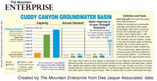
Click on image to see larger version of this bar chart showing groundwater basin capacity and water use by Lake of the Woods and Frazier Park. The third section shows water supply after a severe 10 year drought compared to water use. See Dee Jaspar's Regional Water Supply Study below this story.
By Patric Hedlund, TME –See the civil engineer’s report below
“Save yourself thousands of dollars by voting ‘yes’,” was the take-away message from the last Frazier Park regional water system preplanning meeting.
There was no lobbying by the board of the Frazier Park Public Utility District (FPPUD) for a ‘yes’ vote on the poll sent out to customers in March.
It was the facts and numbers the board reviewed about the state’s annexation incentives that did the talking.
“Our only option for repairing our water system in Frazier Park without taking expensive new loans is to do this annexation,” said FPPUD President Brahma Neyman.
With over $2.75 million in grants over the past 11 years, the district has also had to take three low-interest loans for replacing aging infrastructure. Those cost $158,000 in payments just last year, and there is still much more work to do.
Water customers have a duty to themselves, the board said, to get the facts before they vote on the proposed regional water system with Lake of the Woods.
“The state is offering 100% grants to build a regional water system. If Frazier Park makes the choice to annex the other systems, the grant can include many repairs and upgrades we need on our [FPPUD] system in addition to pipes and other needs for the annexation,” FPPUD Treasurer Lisa Schoenberg said.
“Maybe people still don’t understand,” board member Rebecca Gipson said in last week’s preplanning committee meeting in talking about the poll.
If the annexation is rejected, significantly higher water rates will be inevitable, the board said, because the expensive repairs and infrastructure upgrades to the 80 year old system will still need to be made.
The choice they see ahead is to either annex to create a regional system and apply for the projected $13.5 million in grants that are on offer, or don’t annex and take out loans to do the upgrades that will still be necessary.
The board confirmed at the meeting that in FPPUD’s last fiscal year, current loans for repairs cost $158,000 in principal and interest payments.
The Thursday, March 31 meeting will be at the Frazier Mountain Park Community Center at 6:30 p.m.
The preplanning committee’s consultants, Civil Engineer Dee Jaspar and Self-Help Enterprises Consultant Dave Warner will be there to make presentations about their research regarding water levels and infrastructure upgrade costs. Their mission is to also answer the public’s questions.
The full Regional Water Supply Study by Dee Jaspar and Associates is online with the story, “Water: Get the Facts.”
At the call to the public, the TriCounty Watchdogs delivered a letter addressed to the water companies in the Mountain Communities, asking them to refrain from entering into contracts to provide water to Tejon Ranch Company for their real estate developments.
The TriCounty Watchdogs said that providing water for those who already live here should be the first priority.
___________________
————
“Save yourself thousands of dollars by voting ‘yes’,” was the take-away message from the last Frazier Park regional water system preplanning meeting. There was no lobbying by the board of the Frazier Park Public Utility District (FPPUD) for a ‘yes’ vote on the poll sent out to customers in March. It was the facts and numbers they reviewed about the state’s annexation incentives that did the talking.
“Our only option for repairing our water system in Frazier Park without taking expensive new loans is to do this annexation,” said FPPUD President Brahma Neyman.
With over $2.5 million in grants over the past 11 years, the district has also had to take three low-interest loans for replacing aging infrastructure. Those cost $158,000 in payments just last year, and there is still much more work to do.
Water customers have a duty, the board said, to get the facts before they vote on the proposed regional water system with Lake of the Woods.
“The state is offering 100% grants to build a regional water system. If Frazier Park makes the choice to annex the other systems, the grant can include many repairs and upgrades we need on our [FPPUD] system in addition to pipes and other needs for the annexation,” Treasurer Lisa Schoenfeld said.
There will be one last special public meeting Thursday,
March 31 at 6:30 p.m. at the Frazier Mountain Park
Community Center. Please come get your questions
answered.
“Maybe people still don’t understand,” board member Rebecca Gipson said in last week’s preplanning committee meeting.
If the annexation is rejected, significantly higher water rates will be inevitable. Repairing 80 year old infrastructure is very expensive.
The Thursday, March 31 meeting will be at the Frazier Mountain Park Community Center at 6:30 p.m. The preplanning committee’s consultants, Civil Engineer Dee Jaspar and Self-Help Enterprises Consultant Dave Warner will be there to make presentations about their research regarding water levels and infrastructure upgrade costs. Their mission is to answer the public’s questions.
Here is the study prepared for the FPPUD as part of the preplanning process.
Dee Jaspar & Associates
Regional Water Supply Study
August 27, 2015
To: Frazier Park Public Utility District
4020 Park Drive
Frazier Park, CA 93225
Ladies and Gentlemen:
The following report discusses the availability of groundwater in the Frazier Park – Lake of the Woods portion of the Cuddy Canyon Groundwater Basin. It presents the current understanding of the hydro-geology of the groundwater basin and evaluates the effect of municipal water demands on groundwater storage in the basin.
The report draws on four reports:
- “Groundwater Conditions in the Frazier Park Area” by Kenneth D. Schmidt & Associates – 2015
- “Groundwater Conditions in the Frazier Park/Lebec Specific Plan Area” by Kenneth D. Schmidt & Associates – 2003
- “Regional Groundwater Assessment Report for Cuddy Canyon Groundwater Basin” by the Galli Group – 2008
4. “Estimate of Water Demands for the Study Area” by Dee Jaspar & Assoc., Inc. – 2015
This report utilizes information from the four reports and develops estimates for the combined communities’ water demands and the effects of these demands on the groundwater basin.
Dee Jaspar, P.E.
Introduction
The appended report on “Groundwater Conditions in the Frazier Park Area’ by Ken Schmidt and Associates (KDSA) discusses the subsurface geologic conditions, water levels, well data, well production, groundwater in storage, and sources of recharge, in the Cuddy Creek Canyon Groundwater Basin, and recommends favorable locations for new wells in the Frazier Park area. This report is herein referred to as the “2015 KDSA Report”, to distinguish it from the aforementioned “2003 KDSA Report”.
The communities of Lake of the Woods and Frazier Park, along with many other communities in California, have experienced the damaging effects of the recent four-year drought. It is not certain at this writing when the drought will be broken, or at least, when the state will experience a brief period of wet weather interspersed within the drought period. However, it has been observed that the groundwater basin reacts rapidly to the inflow of water from Cuddy Creek, even during a brief wet period, with the shallow alluvium experiencing various degrees of re-filling depending on creek flow.
Cuddy Canyon Groundwater Basin
The Cuddy Canyon Groundwater Basin was divided into three segments by the Galli Group (2008). These are shown on the attached map. Lake of the Woods is in the West Sub-basin, Frazier Park is in the Middle Sub-basin, and Lebec is in the East Sub-basin. See the appended map. Of interest for this study are the conditions in the West and Middle Sub-basins. These are discussed in the 2015 KDSA Report.
Lake of the Woods has experienced a significant dewatering of the alluvium in the west half of the West Basin with wells penetrating the alluvium showing water levels near or below the base of the alluvium. Water production in the Lake of the Woods wells is currently principally from hard rock underlying the alluvium. The effects of the drought are not as pronounced in Frazier Park. Water levels indicate that the groundwater levels are below what has been termed a “full basin” by Galli, which is 15 feet below ground surface. Levels have remained about 30 feet below ground surface in the Middle Basin over the past year, and they have remained stable at the depth over the past year. This is likely due to adequate recharge and the existence of a restriction to groundwater outflow to the east as described in the 2008 Galli Report. This restriction is near the intersection of the Garlock and the San Andreas Faults. The evidence of this is the difference in water levels west and east of this restriction, with the higher levels being on the west (Frazier Park) side of the restriction and the lower levels being on the east side.
Groundwater Recharge
Groundwater recharge occurs in several ways: 1. Infiltration from Cuddy Creek streamflow, 2. Tributary streams entering from the north and south sides of Cuddy Canyon, 3. Mountain front recharge (underground) from both sides of the valley, 4. Downgradient (easterly) groundwater inflow from the Cuddy Valley Groundwater Basin.
Galli observed that moderate to very large amounts of recharge occurred during small to moderate streamflow events. This happens when rainfall values of 1 to 2 inches occur. The West and Middle Sub-basins benefit the most from these short, powerful storms. Galli also cites the existence of numerous springs and seeps as evidence of significant mountain front recharge, and that this mountain front recharge is a significant contributor to the groundwater basin, particularly in the Frazier Park area. Galli postulated that mountain front recharge is the reason that groundwater levels in the Middle sub-basin remain relatively high, even in periods of drought.
Galli correlated annual rainfall to theoretical basin recharge using infiltration percentages.
The data appears in the following tabulation.
Table 1
| Rainfall Year | Rainfall (in/yr) | Infiltration % | Computed Recharge (acre-feet/year) | Percent of Normal |
| Drought | 0-6 | 0 | 0 | 0 |
| Below Normal | 7-11 | 2-4 | 350 – 1,100 | 35% |
| Normal | 12-15 | 5-7 | 1,500 – 2,600 | 100% |
| Above Normal | 16-20 | 10-15 | 4,000 – 7,500 | 280% |
| Extreme | 20+ | 20+ | >7,500 | 365% |
Galli states that even in years of lower than normal rainfall, but with a day or series of days with 3” – 6” of rainfall, recharge takes place, and therefore the recharge amounts derived in the above table are conservative.
Basin recharge lags behind the rainfall event by a certain time, depending on the configuration of the basin, character of the deposits, and the amount of rainfall. The lag time for the Cuddy Creek Subbasin was calculated as 3 to 4 weeks after significant rainfall event. The basin therefore exhibits the effects of rainfall events relatively quickly.
The 2003 KDSA Report estimated that the average annual groundwater recharge is between 2,000 and 4,000 acre-feet (af) for the Cuddy Canyon Groundwater Basin (Lake of the Woods to Interstate 5). The recharge computed by Galli (above) of between 1,500 and 2,600 acre-feet per year compares favorably to the amounts estimated by KDSA. If the recharge amounts are proportioned by length of sub-basin, the annual average recharge for the West and Middle Sub-basins amounts to about 1,050 acre-feet per year, based on the low range of KDSA’s estimate of recharge (2,000 acre-feet per year for the Cuddy Canyon Groundwater Basin).
Net demand reflects the estimated consumptive use of water that is pumped from the aquifer. It is estimated that household uses return about 75% of the water pumped to the underlying groundwater basin and landscape irrigation returns about 25% of the applied water to the basin. Further, it is estimated that 65% of the water use in the area is household use and 35% is landscape irrigation. Therefore 58% of the water pumped or derived from springs returns to the basin. Barto (1985) used an estimate of 50% for net consumptive use, which is in good agreement.
Water Budget
This firm estimated the total demands for the Lake of the Woods – Frazier Park area in a memorandum dated April 23, 2015. The six-year annual average pumping for Lake of the Woods was 117 acre-feet per year and for Frazier Park the annual average was 360 acre-feet per year, for a combined total of 477 acre-feet per year. 300 additional connections were added to this total to reflect some infill in each entity and existing uses that are not a part of the two entities, bringing the annual water demand to 561 acre-feet for the West and Middle Sub-basins.
The following Demand and Supply tabulation reflects a normal year for the West and Middle Sub-basins. Reference is made to Table 1 for determination of the type of rainfall year.
Table 2
Normal Year – West and Middle Sub-basins
| Year / Rainfall | Recharge (af) | Total Demand (af) | Net Demand (af) | Change in Basin Storage (af) | Basin Storage (af) |
| Normal | 1,050 | 560 | 280 | * | Full (8,300) |
*The difference between recharge and net demand (770 af) is groundwater outflow.
A five-year multiple dry year scenario is presented in Table 3. This table reflects the dry period of 1984 to 1988, one of the driest on record as of now. The basins start the sequence full.
Table 3
Five Year Dry Period – West and Middle Sub-basins
| Year / Rainfall | Recharge (af) | Total Demand (af) | Net Demand (af) | Change in Basin Storage (af) | Basin Storage (af) |
| Normal | 8,300 | ||||
| Dry | 0 | 560 | 280 | -280 | 8,020 |
| Dry | 0 | 560 | 280 | -280 | 7,740 |
| Below Normal* | 180 | 560 | 280 | -100 | 7,640 |
| Below Normal* | 180 | 560 | 280 | -100 | 7,540 |
| Below Normal* | 180 | 560 | 280 | -100 | 7,440 |
*As defined by Galli (Table 1). Recharge assumed to be 17% of normal (17% of 1,050 af) due to mountain front recharge. The recharge percentage used herein is less than predicted by Galli (35%) to reflect conditions between “Dry” and “Below Normal”.
The following Table 4 reflects the effects of an on-going five-year drought, assuming minimal recharge to the groundwater basin, beginning in Year 2014. West Sub-basin dewatered, Middle Sub-basin at 30 feet average depth.
Table 4
Ongoing Drought – West and Middle Sub-basins
| Year / Rainfall | Recharge (af)* | Total Demand (af) | Net Demand (af) | Change in Basin Storage (af) | Basin Storage (af) |
| 2014 | 6,500** | ||||
| 2015 | 0 | 560 | 280 | -280 | 6,220 |
| 2016 | 0 | 560 | 280 | -280 | 5,940 |
| 2017 | 180 | 560 | 280 | -100 | 5,840 |
| 2018 | 180 | 560 | 280 | -100 | 5,740 |
| 2019 | 180 | 560 | 280 | -100 | 5,640*** |
* See footnote, Table 3. Reduced the mountain front recharge to 180 af/yr.
** Current condition in Middle Basin (water levels at 30 feet).
*** Basin 86% full.
Summary and Conclusions
- The Cuddy Canyon Groundwater Basin is divided into three sub-basins: the West, Middle and East Sub-basins. The Cuddy Canyon Groundwater Basin begins at Lake of the Woods and terminates at Interstate 5 in Lebec. It is approximately 36,000 feet long.
- The two sub-basins of concern in this report are the West and Middle Sub-basins.
- The West Sub-basin begins at Lake of the Woods and ends just west of Frazier Park. The Middle Sub-basin begins at the east end of the West Sub-basin and ends just east of Frazier Park. The East Sub-basin begins at the east end of the Middle Sub-basin and ends at Interstate 5.
- Estimated groundwater storage in the Cuddy Canyon Groundwater Basin is 19,600 acre-feet. The groundwater storage in the sub-basins is: West = 1,300 acre-feet, Middle = 7,000 acre-feet, East = 11,300 acre-feet. This reflects “normal” basin conditions as defined by Galli.
- Groundwater recharge is principally from streamflow in Cuddy Creek, from valley side streams, and from Mountain Front recharge.
- Groundwater recharge for the Cuddy Canyon Groundwater Basin in a Normal year has been estimated to be between 1,500 – 2,600 acre-feet per year (Galli Group) to 2,000 – 4,000 acre-feet per year (KDSA). Annual recharge for this study was selected to be the low range of KDSA’s report, 2,000 acre-feet per year. This was used because it is a conservative value and is within the range developed by the Galli Group.
- Existing water demands are 360 acre-feet / year for Frazier Park, 117 acre-feet per year for Lake of the Woods, and 84 acre-feet per year for infill projects and for existing properties between the two entities, bringing the total demands for the West and Middle Sub-basins to 561 acre-feet per year.
- The recharge value is for the entire basin and therefore the recharge value for the combined West and Middle Sub-basins was taken as a ratio of the lengths of the two sub-basins to the full length of the basin. This value was determine to be about 1,050 acre-feet per year for the combined West and Middle Sub-basins.
- In a “Normal” year there is an excess of groundwater from recharge of about 770 acre-feet per year for the West and Middle Sub-basins, which flows underground and into the East Sub-basin.
- A five-year period replicating the Year 1984 – 1988 drought reduces the amount of groundwater in storage from 8,300 acre-feet to 7,440 acre-feet.
- A five-year period of continuing drought beginning in 2015 under current conditions reduces the amount of groundwater in storage in the West and Middle Sub-basins from 6,500 acre-feet to 5,640 acre-feet. Therefore the Middle Basin is 86% full at the end of this period. This demonstrates that the demands created by the combination of the two communities, together with the demands between the two communities, can be met for the next five years if the drought continues and there will be significant storage remaining.
- The Cuddy Canyon Groundwater Basin is sufficient to meet the demands of the combined communities of Frazier Park and Lake of the Woods.
Kenneth D. Schmidt & Associates, Inc. Report
Groundwater Conditions in the Frazier Park Area
Photo captions:
Get the Facts! Public Meeting Thursday, March 31, 6:30 p.m. Frazier Mountain Park Community Center
To see full stories with photos, please purchase a copy of the newspaper at many locations (click this link for a list) throughout the Mountain Communities.
Or, have your newspaper delivered via mail and include internet access. Just call 661-245-3794. Classified ads are FREE to paid subscribers! See front page at www.mountainenterprise.com for details.
The e-Edition is available now with full photos and stories at The Mountain Enterprise e-Edition
(subscriber login required)
This is part of the April 1, 2016 online edition of The Mountain Enterprise.
Have an opinion on this matter? We'd like to hear from you.