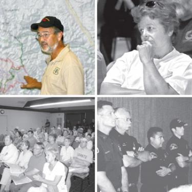
Tim Sexton (top left), Prescribed Fire Manager for the U.S. Forest Service, in California from Washington, D.C. to serve as Deputy Incident Commander of the Zaca fire, explains the plan to stop the advancing blaze. His hand is on the current fire perimeter (in red). The green lines indicate where back fires will be lit, west of Highway 33 (yellow line behind Sexton?s head). At the Saturday, Aug. 11 Zaca fire briefing in Lebec (top right) at Frazier Mountain High School, Terry Murphy and several other Lockwood Valley residents said they are uncomfortable with the plan to light backfires west of Highway 33. They expressed doubts about firefighting agencies? ability to control back-fire fuel burn-outs to be implemented over the next two weeks. No objections were voiced in the Pine Mountain briefing (bottom left). About 60 people attended the briefing in Pine Mountain. Firefighters stood at the back of the room in a row (bottom right), with Pine Mountain?s new manager Dan Rainey (at far right, in white shirt) listening to cautious discussion of evacuation procedures.
By Patric Hedlund
"This will be bigger than the Day fire; it will be the second largest fire in recent history," Los Pinos District Ranger Tom Kuekes said in the first of two Zaca fire briefings held Saturday, Aug. 11.
Though still 20 miles west from the Mountain Communities, and not expected to cross Highway 33, backfire tactics were explained to residents at the Pine Mountain and Lebec gatherings. The "E-word" was raised. Evacuation procedures were described in a flashback to last year when an estimated 85% of the population left their homes.
The briefing focused on plans to light backfires west of Highway 33 and North of Lockwood Valley Road to deplete fuel well before the month-long fire can threaten to jump the road. U.S. Forest Service firefighters, Kern County firefighters and the Kern County Sheriff’s office all participated in the briefings to discuss the strategies and review precautionary evacuation procedures.
As of Wednesday, Aug. 15, the Zaca fire had burned 105,231 acres; 21 helicopters and eight air tankers are on the blaze along with 2,888 personnel at a cost to date of $71.6 million. Firefighters continued with backfiring operation to "burn out" vegetation between the fireline and main fire, which is actively burning in Sisquoc Canyon and Logan Canyon. The backfiring operation is in progress along Sierra Madre Ridge from Sweetwater Ridge to Highway 33. The firing operation is still 10 miles from Highway 33.
U.S. Forest Service Incident Commander Tim Sexton said he anticipates the fire will be contained by September 7.
At the Lebec briefing, several Lockwood Valley residents raised concerns about the plan to light backfires west of Highway 33, saying they believe their properties were damaged last year by backfires set to protect them from the Day fire.
Air Quality Warnings
"These fires are producing large amounts of smoke, which is resulting in elevated particulate readings," said Shawn Ferreria, a meteorologist. "If you smell smoke, you are likely breathing it." Elevated measurements of ash is falling across Kern, Santa Barbara and Ventura Counties. Exposure to particle pollution can aggravate lung disease, cause asthma attacks, acute bronchitis and increase risk of respiratory infections.
Residents are advised to use caution. Older adults and children should avoid prolonged exposure or strenuous activities, as conditions dictate.
Precautionary Closures
The forest closure extends roughly from Highway 166 in northern Santa Barbara County, to east of Highway 33 and south of the Mil Potrero Highway, as well as the Lockwood Valley area. It affects 888,000 acres: the entire San Rafael Wilderness, Matilija Wilderness, Chumash Wilderness, a portion of the Sespe Wilderness, and adjacent national forest lands. The road to Cerro Noroeste (Mt. Able) will be closed. The road to Mt. Pinos summit will remain open, along with the McGill, Mt. Pinos and Chula Vista campgrounds.
The closure prohibits all public entry to national forest lands, trails, roads and recreation sites within the designated area. The public safety closure has been imposed because of the difficulty of evacuating forest visitors from remote areas should the fire spread. In addition, firefighters and heavy equipment are building contingency lines and conducting backfire operations.
—Added reporting from Lebec by Gary Meyer
This is part of the August 17, 2007 online edition of The Mountain Enterprise.
Have an opinion on this matter? We'd like to hear from you.