NWS Detailed Forecast
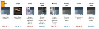
Tuesday
Showers. High near 42. Windy, with a southeast wind 25 to 30 mph, with gusts as high as 40 mph. Chance of precipitation is 80%. New precipitation amounts between a quarter and half of an inch possible.
Tuesday Night
Showers, mainly before 10pm. Low around 35. Breezy, with a south wind 20 to 25 mph, with gusts as high as 35 mph. Chance of precipitation is 80%. New precipitation amounts between a quarter and half of an inch possible.
Wednesday
A 40 percent chance of showers. Mostly cloudy, with a high near 48. Breezy, with a south wind 15 to 20 mph, with gusts as high as 30 mph.
Wednesday Night
Showers likely, mainly after 10pm. Cloudy, with a low around 39. Breezy, with a south wind 20 to 25 mph, with gusts as high as 30 mph. Chance of precipitation is 70%. New precipitation amounts between a quarter and half of an inch possible.
Thursday
Showers, mainly before 4pm. High near 48. Breezy, with a south wind 15 to 20 mph, with gusts as high as 30 mph. Chance of precipitation is 80%. New precipitation amounts between a quarter and half of an inch possible.
Thursday Night
A 50 percent chance of showers, mainly before 10pm. Cloudy, with a low around 35. Breezy, with a west wind 15 to 20 mph, with gusts as high as 30 mph. New precipitation amounts of less than a tenth of an inch possible.
Friday
A 30 percent chance of showers. Cloudy, with a high near 46. Breezy, with a northwest wind around 20 mph, with gusts as high as 30 mph.
Friday Night
Mostly cloudy, with a low around 32. North wind around 15 mph, with gusts as high as 25 mph.
Saturday
Partly sunny, with a high near 52. East northeast wind 10 to 15 mph, with gusts as high as 25 mph.
Saturday Night
Mostly cloudy, with a low around 34. North wind 10 to 15 mph, with gusts as high as 20 mph.
Sunday
Mostly cloudy, with a high near 52. Northeast wind 5 to 15 mph becoming north northwest in the morning.
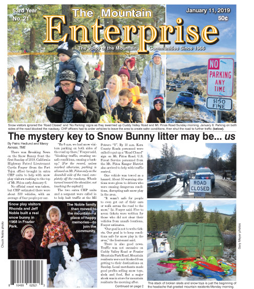
Lebec, Frazier Park, Pine Mountain Club, CA (Monday, Jan. 14, 2019 at 10 a.m.)— Two to four inches of snow clobbered the Mountain Communities from Lebec to Pine Mountain Club this morning.
“All four plow teams are out working,” a spokesperson from PMCPOA said at 9:50 a.m. We’ll be updating about plowing status. [You can phone your reports to 661.245.3794 and email breaking news to BreakingNews(replace with @)MountainEnterprise.com.] Very few vehicles are on the road.
The National Weather Service keeps publishing that there will be rain rather than snow this afternoon, and that accumulation is not expected. Reality: Accumulation has occurred. Drive very carefully, please. Keep those chains in the car, or on the wheels.
And, P.S. All the Mountain Resident Passes printed by the Chamber of Commerce and sold at The Mountain Enterprise and Ace Hardware have been sold. We’ll announce when more are available. Here’s the forecast for this week:
Frazier Park, CA (Saturday, Jan. 12, 2019 at 10 a.m.)— The National Weather Service predicts a squishy week ahead, so get out the galoshes and umbrellas. A gentle snow is falling currently—Perfect weather for careful driving and building awesome snow sculptures. That beautiful snow will be followed by showers, NWS predicts, which may melt the snow, but may also cause ice on the roads. The speed limit in these weather conditions is the speed that keeps you safe and alive.
Drive carefully, even if it is at 25 mph, or even 15 mph when it needs to be. Always carry your chains or spider spikes in your vehicle, no matter whether you have all-wheel or 4-wheel drive. Safety is your guiding beacon.
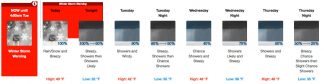
Detailed Forecast
Saturday, January 12, 2019
Showers. The rain could be heavy at times. High near 43. Breezy, with a south southeast wind 15 to 20 mph, with gusts as high as 30 mph. Chance of precipitation is 90%. New precipitation amounts between a quarter and half of an inch possible.
Saturday night
Mostly cloudy, with a low around 30. Breezy, with a south southeast wind around 20 mph, with gusts as high as 30 mph.
Sunday
A 10 percent chance of showers after 5pm. Mostly cloudy, with a high near 46. Breezy, with an east southeast wind 20 to 25 mph, with gusts as high as 30 mph.
Sunday Night
A chance of rain showers before 5am, then a chance of rain and snow showers. Mostly cloudy, with a low around 34. Breezy, with a southeast wind around 25 mph, with gusts as high as 35 mph. Chance of precipitation is 30%.
Monday
A chance of rain and snow showers before 11am, then rain showers likely. Cloudy, with a high near 43. Breezy, with a southeast wind around 25 mph, with gusts as high as 40 mph. Chance of precipitation is 70%. Little or no snow accumulation expected.
Monday Night
Showers likely. Mostly cloudy, with a low around 34. Breezy, with a southeast wind around 25 mph, with gusts as high as 40 mph. Chance of precipitation is 70%. New precipitation amounts between a quarter and half of an inch possible.
Tuesday
Showers. High near 43. Breezy, with a southeast wind 20 to 25 mph, with gusts as high as 35 mph. Chance of precipitation is 80%. New precipitation amounts between a quarter and half of an inch possible.
Tuesday Night
Showers likely, mainly after 5am. Cloudy, with a low around 36. Breezy, with a southeast wind around 25 mph, with gusts as high as 35 mph. Chance of precipitation is 60%. New precipitation amounts between a quarter and half of an inch possible.
Wednesday
Showers likely, mainly before 11am. Mostly cloudy, with a high near 46. Breezy, with a south wind around 20 mph, with gusts as high as 30 mph. Chance of precipitation is 60%. New precipitation amounts between a quarter and half of an inch possible.
Wednesday Night
A 50 percent chance of showers. Cloudy, with a low around 38. Breezy, with a south southeast wind around 20 mph, with gusts as high as 30 mph. New precipitation amounts between a quarter and half of an inch possible.
Thursday
Showers likely. Cloudy, with a high near 47. Windy, with a south wind 25 to 30 mph, with gusts as high as 40 mph. Chance of precipitation is 70%. New precipitation amounts between a half and three quarters of an inch possible.
Thursday Night
A 40 percent chance of showers. Mostly cloudy, with a low around 34. Breezy, with a west wind 20 to 25 mph, with gusts as high as 40 mph.
Friday
A 30 percent chance of showers. Partly sunny, with a high near 48. North northwest wind around 15 mph, with gusts as high as 25 mph.