![[photo by U.S. Geological Survey]](https://mountainenterprise.com/wp-content/uploads/USGS-hwy178-7.1-web-300x400.jpg)
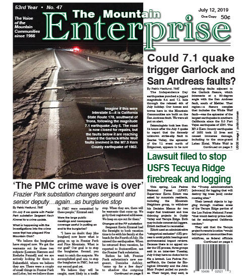
[photo by U.S. Geological Survey]
By Patric Hedlund, TME
The Independence Day earthquakes punched a jagged magnitude 6.4 and 7.1 hole through the relaxed 4th of July holiday.
Our homes and towns here in the Mountain Communities are built on the San Andreas fault. We were all put on alert.
Seismologists took less than 24 hours after the July 5 quake to report that the formerly unknown strike-slip fault in Searles Valley, the epicenter of the 7.1 event north of Ridgecrest, appears to be now activating faults adjacent to the Garlock fissure, which intersects at a 90-degree angle with the San Andreas fault, south of Mettler. That region—a fissure complex that includes the White Wolf fault—was the epicenter of the largest earthquake in southern California since the 8.0 Fort Tejon earthquake of 1857. The M7.3 Kern County earthquake of…(please see below to view full stories and photographs)
Photo captions:
Imagine if this were Interstate 5—it is California State Route 178, southwest of Trona, following the magnitude 7.1 earthquake July 5. The road is now closed for repairs, but the faults below it are reaching toward the Garlock-White Wolf faults involved in the M7.3 Kern County earthquake of 1952.
FAULT LINES, COMMUNITIES AND HIGHWAYS (map not to scale)
To see full stories with photos, please purchase a copy of the newspaper at many locations (click this link for a list) throughout the Mountain Communities.
Or, have your newspaper delivered via mail and include internet access. Just call 661-245-3794. Classified ads are FREE to paid subscribers! See front page at www.mountainenterprise.com for details.
The e-Edition is available now with full photos and stories at The Mountain Enterprise e-Edition. Select the 2019-0712 edition.
(subscriber login required)
This is part of the July 12, 2019 online edition of The Mountain Enterprise.
Have an opinion on this matter? We'd like to hear from you.