Image 1 of 2
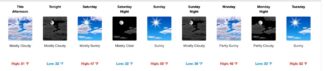
Image 2 of 2
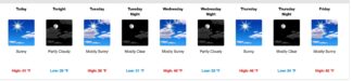
CLICK ON IMAGE TO EXPAND. Forecast from the National Weather Service shows highs in the 40s and 50s for the coming week, with lows dipping into freezing. Drive carefully, that is a recipe for black ice surprises.
Frazier Park, Cuddy Valley, Pine Mountain Club, Lockwood Valley—(Friday, Jan 7, 2022 at 1 p.m.)— Here is the National Weather Service forecast for the coming week. Remember to keep chains in your vehicle, and to anticipate black ice. We will have freezes in the evenings this weekend. That means those beautifully plowed roads may surprise you. Daytime melt from remaining snowbanks on the hillsides can flow across the roads and freeze in the night. Morning commuters, take it slow, please. Evening commuters, temps start to drop as soon as that sun drops behind the mountain. Stay safe folks.
Friday, Jan. 7
Sunny early, then becoming mostly cloudy, with a high near 51. West northwest wind 5 to 10 mph.
Friday night
Mostly cloudy, with a low around 32. West wind around 5 mph.
Saturday
Mostly sunny, with a high near 47. Calm wind becoming west around 5 mph.
Saturday Night
Mostly clear, with a low around 32. East southeast wind around 5 mph.
Sunday
Sunny, with a high near 50. East southeast wind around 10 mph, with gusts as high as 25 mph.
Sunday Night
Mostly cloudy, with a low around 36. Southeast wind around 10 mph, with gusts as high as 20 mph.
Monday
Partly sunny, with a high near 48. East northeast wind around 5 mph, with gusts as high as 20 mph.
Monday Night
Partly cloudy, with a low around 33. East northeast wind around 5 mph, with gusts as high as 15 mph.
Tuesday
Sunny, with a high near 52. East southeast wind 5 to 10 mph becoming northeast in the afternoon. Winds could gust as high as 20 mph.
Tuesday Night
Mostly clear, with a low around 36. East southeast wind around 5 mph, with gusts as high as 15 mph.
Wednesday
Sunny, with a high near 55. Southeast wind around 5 mph becoming east northeast in the afternoon. Winds could gust as high as 15 mph.
Wednesday Night
Partly cloudy, with a low around 35. South southeast wind around 5 mph.
Thursday
Mostly sunny, with a high near 49. South southeast wind around 5 mph becoming northwest in the afternoon. Winds could gust as high as 15 mph.
Frazier Park, Cuddy Valley, Pine Mountain Club, Lockwood Valley—(Monday, Jan 3, 2022 at 8 a.m.)—Snow play areas are open. The road to Mount Pinos is open. But you should have chains in your vehicle. There is slippery ice lurking on otherwise clear roads throughout the mountain.
Here is the National Weather Service forecast for this week, through the weekend.
Daytime sunshine will thaw snow. Nights will be freezing, which means daytime snow melt will freeze on the road at night.
Careful, slow, driving is wise. Keep yourself and your loved ones safe. Drive slowly and stay alert. Get there safely. Make this a healthy, safe and happy new year.
Monday, Jan. 3, 2022
Sunny, with a high near 41. West wind around 10 mph, with gusts as high as 15 mph.
Monday night
Partly cloudy, with a low around 29. West northwest wind around 15 mph, with gusts as high as 20 mph.
Tuesday
Mostly sunny, with a high near 38. North northwest wind around 15 mph, with gusts as high as 25 mph.
Tuesday Night
Mostly clear, with a low around 31. Northwest wind around 15 mph, with gusts as high as 20 mph.
Wednesday
Mostly sunny, with a high near 40. Northwest wind around 15 mph, with gusts as high as 25 mph.
Wednesday Night
Partly cloudy, with a low around 33. Northwest wind around 15 mph, with gusts as high as 20 mph.
Thursday
Sunny, with a high near 46. Northwest wind around 10 mph, with gusts as high as 20 mph.
Thursday Night
Mostly clear, with a low around 34. West southwest wind around 10 mph, with gusts as high as 15 mph.
Friday
Mostly sunny, with a high near 42. West southwest wind 10 to 15 mph.
Friday Night
Mostly cloudy, with a low around 34. West southwest wind around 15 mph.
Saturday
Partly sunny, with a high near 40. West wind 10 to 15 mph.
Saturday Night
Partly cloudy, with a low around 32. South wind around 15 mph.
Sunday
Mostly sunny, with a high near 42. East southeast wind around 15 mph, with gusts as high as 20 mph.
LAST WEEK:
Friday, Dec. 31, 2021
A 20% chance of snow showers before 9 a.m. Mostly sunny, with a temperature rising to near 29 by 9am, then falling to around 24 during the remainder of the day. Northwest wind around 15 mph, with gusts as high as 30 mph.
Friday Night
Partly cloudy, with a steady temperature around 23. Blustery, with a northwest wind around 20 mph, with gusts as high as 30 mph.
New Year’s Day
Sunny, with a high near 35. North northwest wind 10 to 15 mph.
Saturday Night
Clear, with a low around 25. East wind around 15 mph.
Sunday
Sunny, with a high near 37. North northeast wind 10 to 15 mph.
Sunday Night
Mostly clear, with a low around 27. South southwest wind around 10 mph.
Monday
Sunny, with a high near 38. West wind around 10 mph.
Monday Night
Partly cloudy, with a low around 27. West wind 10 to 15 mph.
Tuesday
Mostly sunny, with a high near 38. North northwest wind 10 to 15 mph.
Tuesday Night
Mostly clear, with a low around 31. Northwest wind around 15 mph.
Wednesday
Sunny, with a high near 41. West northwest wind around 15 mph, with gusts as high as 20 mph.
Wednesday Night
Partly cloudy, with a low around 34. West northwest wind around 15 mph.
Thursday
Sunny, with a high near 45. North northwest wind 10 to 15 mph.
LEBEC, CA (Thursday, Dec. 30, 2021 at 3:45 p.m.)—Interstate 5 is now open in both directions with escorts.
LEBEC, CA (Thursday, Dec. 30, 2021 at 3:33 p.m.)—All southbound lanes of Interstate 5 are open and northbound should be open by 3:50 p.m., according to CHP.
LEBEC, CA (Thursday, Dec. 30, 2021 at 8:33 a.m.)—CHP has closed westbound 138 at 245th Street West due to heavy snow.
LEBEC, CA (Thursday, Dec. 30, 2021 at 8:18 a.m.)—Kern County closed Hudson Ranch Road at 7 a.m. between Highway 166/33 and Pine Mountain Club due to heavy snow.
LEBEC, CA (Thursday, Dec. 30, 2021 at 7:56 a.m.)—CHP is considering closing eastbound 138 just east of I-5 as heavy snow has accumulated there.
LEBEC, CA (Thursday, Dec. 30, 2021 at 7:46 a.m.)—CHP has closed access to Frazier Mountain communities from all side roads. Onramps to get OFF the mountain are also closed. No travel on the Grapevine is being allowed in any direction.
LEBEC, CA (Thursday, Dec. 30, 2021 at 7:01 a.m.)—Southbound traffic is being turned around at Grapevine Road. Northbound traffic is being turned around in Castaic at Lake Hughes Road.
LEBEC, CA (Thursday, Dec. 30, 2021 at 6:54 a.m.)—There are no alternate routes to get up to Frazier Mountain communities from Los Angeles or Bakersfield. There are only routes to get AROUND the Grapevine.
LEBEC, CA (Thursday, Dec. 30, 2021 at 5:43 a.m.)—CHP has closed the Grapevine in both directions.
LEBEC, CA (Thursday, Dec. 30, 2021 at 6:53 a.m.)—CHP reports that snow is sticking at the summit on I-5.
This is part of the January 7, 2022 online edition of The Mountain Enterprise.
Have an opinion on this matter? We'd like to hear from you.