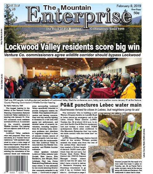
Image 1 of 2
Double click for larger image.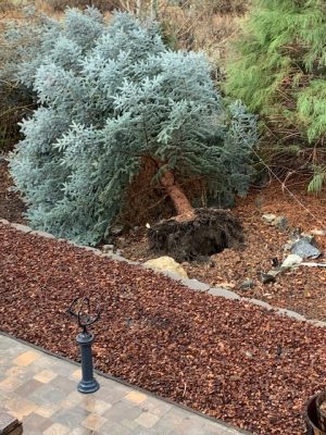
Image 2 of 2
This beautiful tree was uprooted by a wind gust in Pine Mountain Club on Thursday morning.
FRAZIER PARK, CA (Thursday, Feb. 14, 2019 at 11 a.m.)—Heavy wind gusts have lifted a tree out of the ground in Pine Mountain Club. Intermittent showers continue. See the full National Weather Service forecast below.
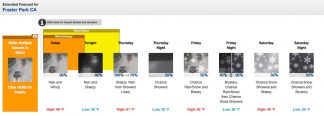
Detailed Forecast
Thursday, Feb. 14, 2019
Rain before 10am, then showers likely after 10am. High near 51. Breezy, with a south wind around 25 mph, with gusts as high as 55 mph. Chance of precipitation is 100%. New precipitation amounts between a quarter and half of an inch possible.
Thursday Night
A 50 percent chance of showers. Mostly cloudy, with a low around 30. Southwest wind around 15 mph, with gusts as high as 25 mph. New precipitation amounts of less than a tenth of an inch possible.
Friday
A chance of rain and snow showers. Mostly cloudy, with a high near 40. Breezy, with a west wind around 20 mph, with gusts as high as 30 mph. Chance of precipitation is 50%. Little or no snow accumulation expected.
Friday Night
A chance of rain and snow showers before 10pm, then a chance of snow showers. Mostly cloudy, with a low around 26. Blustery, with a west northwest wind around 20 mph, with gusts as high as 30 mph. Chance of precipitation is 40%.
Saturday
A 50 percent chance of snow showers, mainly after 10am. Partly sunny, with a high near 40. Breezy, with a northwest wind 20 to 25 mph, with gusts as high as 35 mph. New snow accumulation of less than a half inch possible.
Saturday Night
A 50 percent chance of snow showers. Partly cloudy, with a low around 25. Blustery, with a northwest wind around 20 mph, with gusts as high as 30 mph.
Sunday
Snow showers, mainly after 10am. High near 37. Breezy, with a west northwest wind 15 to 20 mph, with gusts as high as 30 mph. Chance of precipitation is 80%.
Sunday Night
Snow showers likely, mainly before 10pm. Mostly cloudy, with a low around 24. Blustery, with a west northwest wind around 20 mph, with gusts as high as 30 mph. Chance of precipitation is 60%.
Monday (Presidents Day)
A 30 percent chance of snow showers. Mostly sunny, with a high near 35. Breezy, with a northwest wind around 20 mph, with gusts as high as 30 mph.
Monday Night
Mostly clear, with a low around 21. Blustery, with a north northwest wind around 20 mph, with gusts as high as 30 mph.
Tuesday
Sunny, with a high near 39. North wind around 15 mph, with gusts as high as 20 mph.
FRAZIER PARK, CA (Wednesday, Feb. 13, 2019 at 8:55 a.m.)—The National Weather Service has issued two weather advisories for today (Wednesday, Feb. 13). A wind advisory is in effect for mountain regions in Kern County through 10 p.m. tonight. Predictions of heavy rain has many Kern County towns and cities on flood watch. See both weather advisories below followed by this week’s forecast.
Wind Advisory in effect until 10 p.m. Wednesday
URGENT – WEATHER MESSAGE
National Weather Service Hanford CA
857 AM PST Wed Feb 13 2019
Kern County Mountains-
Including the city of Tehachapi
857 AM PST Wed Feb 13 2019
…WIND ADVISORY REMAINS IN EFFECT UNTIL 10 PM PST THIS EVENING…
* WINDS…South 15 to 25 mph with gusts up to 60 mph.
* TIMING…Winds will be strongest through and below the Grapevine this afternoon and evening.
* IMPACTS…Damaging winds will blow down trees and power lines. Widespread power outages are expected. Travel will be difficult, especially for high profile vehicles.
PRECAUTIONARY/PREPAREDNESS ACTIONS…
A Wind Advisory means that winds of 35 mph are expected. Winds this strong can make driving difficult, especially for high profile vehicles. Use extra caution.
Flood Watch in effect through Thursday, 10 a.m.
Flood Watch
National Weather Service Hanford CA
516 AM PST Wed Feb 13 2019
Mariposa, Madera, and Fresno County Foothills-Tulare County Foothills-Kern County Mountains-Sierra Nevada from Yosemite to Kings Canyon-Tulare County Mountains-Including the cities of Coarsegold, Oakhurst, Squaw Valley, Auberry, North Fork, Mariposa, Springville, Three Rivers, Tehachapi, Lake Isabella, Devils Postpile, Florence Lake, Lake Thomas Edison, Tuolumne Meadows, Bass Lake, Fish Camp, Wawona, Camp Nelson, Giant Forest, Lodgepole, Grant Grove, and Johnsondale
516 AM PST Wed Feb 13 2019
…FLOOD WATCH REMAINS IN EFFECT THROUGH THURSDAY MORNING…
The Flood Watch continues for
* A portion of central California, including the following areas, Kern County Mountains, Mariposa, Madera, and Fresno County Foothills, Sierra Nevada from Yosemite to Kings Canyon, Tulare County Foothills, and Tulare County Mountains.
* Through Thursday morning
* Heavy rain will overspread much of the area today and persist through Thursday morning. Rain on top of snow will potentially create flooding concerns in the Southern Sierra Nevada below 5,000 feet.
* Rivers and streams will rise on Wednesday as rain increases through the day. Street flooding and mudslides are also possible in foothill communities.
PRECAUTIONARY/PREPAREDNESS ACTIONS…
A Flood Watch means there is a potential for flooding based on current forecasts. You should monitor later forecasts and be alert for possible Flood Warnings. Those living in areas prone to flooding should be prepared to take action should flooding develop.
FRAZIER PARK, CA (Saturday, Feb. 9, 2019)—See the detailed forecast below.
Saturday, February 9, 2019
Mostly cloudy, with a low around 23. Breezy, with a southwest wind 15 to 20 mph, with gusts as high as 35 mph.
Sunday
Snow showers. High near 31. Breezy, with a southwest wind 20 to 25 mph becoming northwest in the afternoon. Winds could gust as high as 45 mph. Chance of precipitation is 90%. New snow accumulation of 3 to 5 inches possible.
Sunday Night
A 40 percent chance of snow showers before 10pm. Mostly cloudy, with a low around 17. Wind chill values as low as -1. Blustery, with a north northwest wind 20 to 25 mph, with gusts as high as 40 mph.
Monday
Sunny, with a high near 35. North northwest wind around 15 mph becoming east northeast in the morning. Winds could gust as high as 30 mph.
Monday Night
Partly cloudy, with a low around 22. Light southeast wind becoming south southeast 10 to 15 mph in the evening. Winds could gust as high as 30 mph.
Tuesday
Mostly cloudy, with a high near 42. Breezy, with a southeast wind 15 to 20 mph, with gusts as high as 30 mph.
Tuesday Night
Snow likely, mainly after 4am. Cloudy, with a low around 30. Breezy, with a southeast wind 20 to 25 mph, with gusts as high as 30 mph. Chance of precipitation is 60%. New snow accumulation of less than one inch possible.
Wednesday
Rain and snow likely before 8am, then rain. High near 40. Windy, with a south southeast wind 30 to 40 mph, with gusts as high as 50 mph. Chance of precipitation is 80%. New precipitation amounts between a half and three quarters of an inch possible.
Wednesday Night
Rain likely before 9pm, then rain and snow likely between 9pm and 11pm, then a chance of snow after 11pm. Mostly cloudy, with a low around 28. Windy, with a southeast wind 30 to 35 mph becoming north northwest in the evening. Winds could gust as high as 45 mph. Chance of precipitation is 70%. New precipitation amounts between a tenth and quarter of an inch possible.
Thursday
A 40 percent chance of snow. Mostly sunny, with a high near 40. Windy, with a northwest wind 25 to 30 mph, with gusts as high as 40 mph.
Thursday Night
A 20 percent chance of snow. Mostly cloudy, with a low around 28. Northeast wind around 15 mph becoming southeast in the evening. Winds could gust as high as 25 mph.
Friday
A chance of rain and snow. Cloudy, with a high near 42. Breezy, with a south southeast wind around 20 mph, with gusts as high as 30 mph. Chance of precipitation is 30%.
Friday Night
A chance of rain and snow. Cloudy, with a low around 31. Breezy, with a southwest wind 15 to 20 mph, with gusts as high as 30 mph. Chance of precipitation is 40%.
Saturday
A chance of rain and snow. Cloudy, with a high near 40. Windy, with a west wind 25 to 30 mph, with gusts as high as 35 mph. Chance of precipitation is 50%. New precipitation amounts between a tenth and quarter of an inch possible.
This is part of the February 8, 2019 online edition of The Mountain Enterprise.
Have an opinion on this matter? We'd like to hear from you.