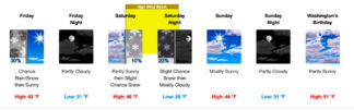
Click on Image to enlarge. The National Weather Service predicts a cold Thursday, Friday and Saturday with a chance of rain and snow, turning to partly sunny skies by Sunday.
UPDATE—The Grapevine, Frazier Park, Pine Mountain Club, Cuddy Valley, Lebec, Lockwood Valley (Friday, Feb. 12, 2021, 9 a.m.)—Cold wind gusts and precipitation have brought frost and a dusting of snow in sections of the Mountain Communities this morning. Please drive slowly and carefully. Beware of icy patches on the roadways. Scroll down to see the detailed forecast.
UPDATE—The Grapevine, Frazier Park, Pine Mountain Club, Cuddy Valley, Lebec, Lockwood Valley (Thursday, Feb. 11, 2021, 1:40 p.m.)— Expect a tug of war between winter and spring this week. Clouds and cold nights will see lows in the 30s to raise a 10%-30% chance of snow late Thursday, early Friday and Saturday, with the sun returning on Sunday, Monday and Tuesday. Highs will descend to the 40s. Winds are a moderate 5-15 mph, with occasional 30 mph gusts.
Detailed Forecast
UPDATE—The Grapevine, Frazier Park, Pine Mountain Club, Cuddy Valley, Lebec, Lockwood Valley (Thursday, Feb. 4, 2021, 5:40 a.m.)—Time to recover from the high winds and storms of last week, this will be a week of highs in the 50s, and clear skies. It looks like spring is around the corner. Winds will be calm at around 5 mph and lows will be just at freezing or above. No precipitation is predicted.
Detailed Forecast
UPDATE—The Grapevine, Frazier Park, Pine Mountain Club, Cuddy Valley, Lebec, Lockwood Valley (Monday, Feb. 1, 2021, 8 a.m.)—
Wow. High near 53 on Monday, and sun! Go take care of all those errands today, with a smile! Tuesday will have sun as well but snow may return by Wednesday. The rest of the week will also be partly cloudy, but no further forecast for snow or rain—check back, we’ll update if that changes.
Detailed Forecast
UPDATE—The Grapevine, Frazier Park, Pine Mountain Club, Cuddy Valley, Lebec, Lockwood Valley (Friday Jan. 29, 2021, 7 p.m.)—Detailed Forecast
UPDATE—The Grapevine, Frazier Park, Pine Mountain Club, Cuddy Valley, Lebec, Lockwood Valley (Tuesday, Jan. 26, 2021, 7 p.m.)—Detailed Forecast
The Grapevine, Frazier Park, Pine Mountain Club, Cuddy Valley, Lebec, Lockwood Valley (Monday, Jan. 25, 2021 at 4:30 p.m.)—Icy, icy winds. And there is a thin snow falling. A bit of sun is promised Tuesday, with more snow after 4 a.m. Wednesday—70% probability of snow Wednesday and Thursday. Scroll down for National Weather Service forecast.
The Grapevine, Frazier Park, Pine Mountain Club, Cuddy Valley, Lebec, Lockwood Valley (Monday, Jan. 25, 2021, 7 a.m.)—It snowed through the night. Though very cold and windy, the snow was fairly sparse, about an inch. Be cautious! It will be very icy on our roads. Have your chains / spikes / traction devices with you. Drive slowly. Watch for surprises. The high is forecast as 30 degrees, with wind gusts up to 40 mph, 70% chance of precipitation, and snow accumulation up to 3 inches Good news? Tuesday is expected to be sunny with snow returning again on Wednesday through Friday, and maybe the weekend. Be happy. Drive slowly. Get there safely.
The Grapevine, Frazier Park, Pine Mountain Club, Cuddy Valley, Lebec, Lockwood Valley (Saturday, Jan. 23, 2021)— Winter is back. Temperatures are dropping, precipitation is increasing from Tuesday night through Friday. Saturday six accidents were reported already, with just an inch of snow. Icy roads are not our friend. Slow down people. Carry chains / traction devices, and drive very carefully. You have precious cargo on board. You! Get there safe.
Detailed Forecast
This is part of the February 12, 2021 online edition of The Mountain Enterprise.
Have an opinion on this matter? We'd like to hear from you.