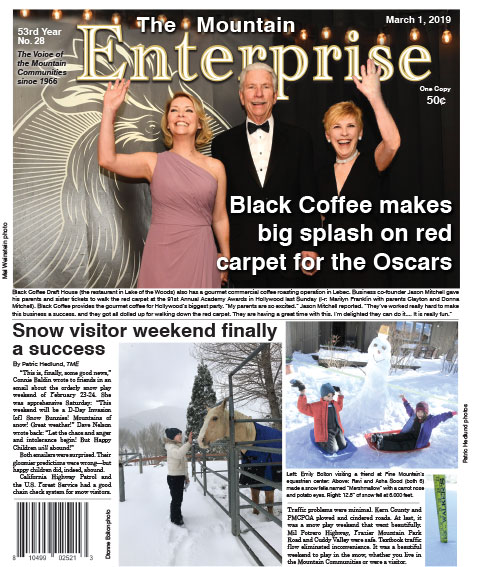
Double click to enlarge this image.
FRAZIER PARK, CA (Thursday, March 7, 2019 at 2:15 p.m.)—A Winter Weather Advisory has been issued by the National Weather Service. There is a 60% chance of precipitation today and tomorrow.
NWS Winter Weather Advisory
…WINTER WEATHER ADVISORY REMAINS IN EFFECT FROM 8 PM THIS EVENING TO NOON PST FRIDAY ABOVE 3000 FEET… *
TIMING…8 PM tonight through noon Friday. The worst conditions will likely occur between 3 AM and 8 AM. *
MAIN IMPACT…Up to 2 inches of snow may fall on passes above 3,000 feet. Highways effected include Interstate 5 through the Grapevine and Highway 58 through Tehachapi Pass. *
OTHER IMPACTS…Wet roads could become icy over the passes this evening as cold air moves into the region. This could lead to travel delays or possible road closures.
PRECAUTIONARY/PREPAREDNESS ACTIONS… A Winter Weather Advisory means that periods of snow, or freezing rain will cause travel difficulties. Be prepared for slippery roads and limited visibilities, and use caution while driving. A Winter Weather Advisory for snow means that periods of snow will cause primarily travel difficulties. Be prepared for snow covered roads and limited visibilities, and use caution while driving.
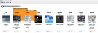
Detailed Forecast
Thursday Afternoon
Showers likely. Partly sunny, with a high near 44. South southwest wind around 5 mph becoming northwest. Chance of precipitation is 60%. New precipitation amounts of less than a tenth of an inch possible.
Thursday Night
Rain showers likely before 10pm, then snow showers likely. Mostly cloudy, with a low around 27. South southwest wind 5 to 10 mph becoming west northwest after midnight. Winds could gust as high as 15 mph. Chance of precipitation is 70%. New snow accumulation of less than one inch possible.
Friday
Snow showers likely, mainly before 10am. Mostly sunny, with a high near 37. Breezy, with a north northwest wind 15 to 20 mph, with gusts as high as 30 mph. Chance of precipitation is 60%. New snow accumulation of less than a half inch possible.
Friday Night
Partly cloudy, with a low around 24. Northwest wind 10 to 15 mph.
Saturday
Mostly sunny, with a high near 40. Northwest wind 5 to 10 mph becoming southwest in the afternoon.
Saturday Night
Mostly cloudy, with a low around 27. Northwest wind around 5 mph.
Sunday
A 50 percent chance of snow showers after 10am. Mostly cloudy, with a high near 41. North wind around 15 mph becoming east northeast in the morning. Winds could gust as high as 20 mph. New snow accumulation of less than a half inch possible.
Sunday Night
A 40 percent chance of snow showers, mainly before 10pm. Mostly cloudy, with a low around 27. North northwest wind 10 to 15 mph.
Monday
A chance of snow showers before 1pm, then a chance of rain and snow showers. Mostly sunny, with a high near 43. North wind 10 to 15 mph, with gusts as high as 20 mph. Chance of precipitation is 30%.
Monday Night
Mostly clear, with a low around 28. Northwest wind around 15 mph, with gusts as high as 25 mph.
Tuesday
A chance of rain and snow showers. Mostly sunny, with a high near 45. Breezy, with a northwest wind 15 to 20 mph, with gusts as high as 30 mph. Chance of precipitation is 30%.
Tuesday Night
A chance of rain and snow showers. Mostly cloudy, with a low around 28. Windy, with a north northwest wind 25 to 30 mph, with gusts as high as 40 mph. Chance of precipitation is 30%.
Wednesday
A 20 percent chance of snow showers. Mostly sunny, with a high near 43. Windy, with a north wind 25 to 30 mph, with gusts as high as 40 mph.
FRAZIER PARK, CA (MONDAY, March 4, 2019 at 5:15 p.m.)—Here’s the National Weather Service forecast for the week.
Detailed Forecast
Monday Night
Partly cloudy, with a low around 36. Northwest wind around 10 mph becoming southwest in the evening.
Tuesday
Rain, mainly after 11am. High near 54. South wind around 15 mph, with gusts as high as 25 mph. Chance of precipitation is 90%. New precipitation amounts between a quarter and half of an inch possible.
Tuesday Night
Rain. Low around 38. Breezy, with a southeast wind 20 to 25 mph, with gusts as high as 30 mph. Chance of precipitation is 90%. New precipitation amounts between a half and three quarters of an inch possible.
Wednesday
Rain before 10am, then showers likely and possibly a thunderstorm after 10am. High near 49. Breezy, with a south wind 20 to 25 mph, with gusts as high as 35 mph. Chance of precipitation is 90%. New rainfall amounts between a quarter and half of an inch possible.
Wednesday Night
A 40 percent chance of showers. Cloudy, with a low around 36. South wind around 15 mph, with gusts as high as 25 mph.
Thursday
Showers likely, mainly after 10am. Mostly cloudy, with a high near 46. Southwest wind around 15 mph, with gusts as high as 20 mph. Chance of precipitation is 60%. New precipitation amounts of less than a tenth of an inch possible.
Thursday Night
Rain showers likely before 9pm, then rain and snow showers likely between 9pm and 1am, then snow showers likely after 1am. Mostly cloudy, with a low around 31. West southwest wind around 15 mph, with gusts as high as 25 mph. Chance of precipitation is 60%. New snow accumulation of less than a half inch possible.
Friday
Snow showers likely before noon, then rain showers likely between noon and 3pm, then snow showers likely after 3pm. Mostly cloudy, with a high near 39. Breezy, with a northwest wind around 20 mph, with gusts as high as 30 mph. Chance of precipitation is 70%. New precipitation amounts of less than a tenth of an inch possible.
Friday Night
A 40 percent chance of snow showers, mainly before 10pm. Partly cloudy, with a low around 27. Blustery, with a northwest wind around 25 mph, with gusts as high as 30 mph.
Saturday
Sunny, with a high near 44. North northwest wind around 15 mph, with gusts as high as 25 mph.
Saturday Night
Mostly cloudy, with a low around 30. West wind around 15 mph becoming south in the evening. Winds could gust as high as 20 mph.
Sunday
A 40 percent chance of showers. Mostly cloudy, with a high near 44. Southeast wind around 15 mph, with gusts as high as 20 mph.
Sunday Night
A chance of rain and snow showers. Mostly cloudy, with a low around 31. East southeast wind 10 to 15 mph, with gusts as high as 20 mph. Chance of precipitation is 40%.
Monday
Rain and snow showers likely. Mostly cloudy, with a high near 43. Northeast wind 10 to 15 mph, with gusts as high as 20 mph. Chance of precipitation is 60%. New precipitation amounts between a tenth and quarter of an inch possible.
This is part of the March 1, 2019 online edition of The Mountain Enterprise.
Have an opinion on this matter? We'd like to hear from you.