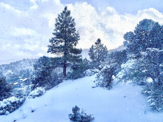
WEATHER FORECAST UPDATES—Carry Chains, Watch for Black Ice

  • Image 1 of 2

  • At 7 a.m. Monday, Dec. 28 a belated White Christmas is covering the Mountain Communities. During the night the snow was heavy and wet, with dawn it is light and dry.

    Image 2 of 2
    At 7 a.m. Monday, Dec. 28 a belated White Christmas is covering the Mountain Communities. During the night the snow was heavy and wet, with dawn it is light and dry.

UPDATE—Frazier Park, Lebec, Pine Mountain Club, Cuddy Valley, Lockwood Valley, CA and the Grapevine section of Interstate 5 (Monday, Jan. 4, 2020 at 10:30 a.m.)—A chilly wind is picking up slightly. There is a chance of rain and possibly some snow Monday night, with sun returning by Wednesday. “Partly Cloudy” and “Sunny” chase each other through the week, with mild winds and temperatures as low as 29 and as high as 52 predicted through the week.

Drive cautiously. Remember that sun melts snow and plummeting temperatures turn that melt on the roads into black ice. During this season, always have your chains with you and ready to use. Most importantly, plan ahead so you can drive slowly. Don’t be caught by surprise by sudden skidding. Be especially cautious on mountain curves and bridges. Slow down. Get there safely.

Monday Afternoon, January 4

Increasing clouds, with a temperature falling to around 45 by 5 pm. Northwest wind around 15 mph, with gusts as high as 25 mph.
Monday Night
A slight chance of showers before 10pm, then a slight chance of showers after 11pm. Snow level 7200 feet lowering to 6000 feet after midnight . Mostly cloudy, with a low around 32. Northwest wind around 15 mph, with gusts as high as 25 mph. Chance of precipitation is 20%.
Tuesday
Sunny, with a high near 55. Northwest wind 5 to 10 mph becoming east northeast in the morning.
Tuesday Night
Partly cloudy, with a low around 32. South southeast wind around 5 mph becoming east northeast after midnight. Winds could gust as high as 15 mph.
Wednesday
Mostly sunny, with a high near 55. North northeast wind around 5 mph.
Wednesday Night
Partly cloudy, with a low around 32. North northwest wind around 5 mph, with gusts as high as 15 mph.
Thursday
Mostly sunny, with a high near 53. North wind 5 to 10 mph, with gusts as high as 15 mph.
Thursday Night
Mostly clear, with a low around 32. North northwest wind around 5 mph.
Friday
Mostly sunny, with a high near 54. North northwest wind 5 to 10 mph, with gusts as high as 20 mph.
Friday Night
Partly cloudy, with a low around 30. Northwest wind around 10 mph, with gusts as high as 20 mph.
Saturday
Mostly sunny, with a high near 49. North wind around 10 mph, with gusts as high as 20 mph.
Saturday Night
Partly cloudy, with a low around 29. Northeast wind around 5 mph, with gusts as high as 15 mph.
Sunday
Mostly sunny, with a high near 52. Northeast wind around 10 mph, with gusts as high as 20 mph.
UPDATE—Frazier Park, Lebec, Pine Mountain Club, Cuddy Valley, Lockwood Valley, CA and the Grapevine section of Interstate 5 (Friday, Jan. 1, 2020 at 10:30 a.m.)—Happy New Year—Welcome to 2021. Enjoy a sunny day today. Drive carefully. Watch for black ice.
New Year’s Day
Sunny, with a high near 49. South wind 10 to 15 mph.
Friday Night
Partly cloudy, with a low around 29. West wind 5 to 10 mph, with gusts as high as 15 mph.
Saturday
Mostly sunny, with a high near 51. Northwest wind around 5 mph, with gusts as high as 15 mph.
Saturday Night
Partly cloudy, with a low around 32. West northwest wind around 5 mph.
Sunday
Partly sunny, with a high near 50. Northwest wind 5 to 10 mph, with gusts as high as 15 mph.
Sunday Night
Mostly cloudy, with a low around 33. West northwest wind around 5 mph.
Monday
A 30 percent chance of showers after 10am. Snow level 7400 feet. Partly sunny, with a high near 51. West wind 5 to 10 mph, with gusts as high as 20 mph.
Monday Night
A 30 percent chance of showers, mainly before 10pm. Snow level 6400 feet lowering to 5400 feet after midnight . Mostly cloudy, with a low around 30. Northwest wind around 10 mph, with gusts as high as 25 mph.
Tuesday
Mostly sunny, with a high near 46. North northwest wind around 10 mph, with gusts as high as 20 mph.
Tuesday Night
Partly cloudy, with a low around 30. West northwest wind 5 to 10 mph, with gusts as high as 15 mph.
Wednesday
A 30 percent chance of showers. Snow level 5600 feet rising to 6400 feet in the afternoon. Partly sunny, with a high near 51. Northwest wind 5 to 10 mph, with gusts as high as 20 mph.
UPDATE—Frazier Park, Lebec, Pine Mountain Club, Cuddy Valley, Lockwood Valley, CA and the Grapevine section of Interstate 5 (Thursday, Dec. 31, 2020 at 8:30 a.m.)
Thursday, Dec. 31, 2020
A 30 percent chance of snow showers before 10am. Snow level 4700 feet. Mostly cloudy, then gradually becoming sunny, with a high near 39. Breezy, with a northwest wind 15 to 20 mph, with gusts as high as 40 mph.
Tonight
Mostly clear, with a steady temperature around 31. West wind 5 to 10 mph becoming south southwest in the evening.

UPDATE—Frazier Park, Lebec, Pine Mountain Club, Cuddy Valley, Lockwood Valley, CA and the Grapevine section of Interstate 5 (Tuesday, Dec. 29, 2020 at 8:30 p.m.) —On cue, the sun returned today and snow has begun to melt. Wednesday is forecast to rise into the mid-40s, with the low Wednesday night at 29ºF. It will be cold, but not wet. Drive carefully and slowly. Beware of black ice.  —Scroll down to see full weather report.

Tuesday Night
Mostly clear, with a low around 26. North northeast wind around 5 mph.
Wednesday
Mostly sunny, with a high near 46. North northwest wind around 5 mph.
Wednesday Night
Partly cloudy, with a low around 29. North northwest wind around 5 mph.
Thursday
Mostly sunny, with a high near 42. North northwest wind 5 to 10 mph.
Thursday Night
Partly cloudy, with a low around 26. North wind around 5 mph.
New Year’s Day
Sunny, with a high near 48. East northeast wind around 5 mph.
Friday Night
Partly cloudy, with a low around 32. Calm wind.
Saturday
Mostly sunny, with a high near 51. Northwest wind around 5 mph.
Saturday Night
Partly cloudy, with a low around 33. Calm wind becoming west northwest around 5 mph.
Sunday
A 20 percent chance of rain. Snow level 6200 feet. Mostly sunny, with a high near 49. Northwest wind around 5 mph.
Sunday Night
Partly cloudy, with a low around 33. Northwest wind around 5 mph.
Monday
A chance of rain and snow. Snow level rising to 6500 feet in the afternoon. Mostly sunny, with a high near 50. West northwest wind around 5 mph. Chance of precipitation is 30%.

UPDATE—Frazier Park, Lebec, Pine Mountain Club, Cuddy Valley, Lockwood Valley, CA and the Grapevine section of Interstate 5 (Monday, Dec. 28, 2020 at 4:30 p.m.) — The primary surge of snow will be over tonight with a prediction for a high of 38 on Tuesday, which will be cloudy. Sun will return on Wednesday. Winds will be gentle through the week. New Year’s Day will be sunny. So cheer up! Drive with caution. Keep your chains in your vehicle. Watch for those icy patches.

Monday night, Dec. 28, 2020
A 30 percent chance of snow, mainly between 8pm and 10pm. Mostly cloudy, with a low around 27. North wind around 5 mph becoming southeast after midnight.
Tuesday
Mostly cloudy, then gradually becoming sunny, with a high near 38. Calm wind becoming north northeast around 5 mph.


UPDATE—Frazier Park, Lebec, Pine Mountain Club, Cuddy Valley, Lockwood Valley, CA and the Grapevine section of Interstate 5 (Monday, Dec. 28, 2020 at 8 a.m.) —At 7 a.m. Monday, Dec. 28 a belated White Christmas snow—up to three to eight inches— is covering the Mountain Communities. During the night the snow was heavy and wet. With dawn it is light and dry.

Be sure to drive very carefully. Plowing is just beginning. Cindering is starting slowly.  Mil Potrero is plowed but not cindered in Pine Mountain Club. Kern County Roads workers have been out and are tending the main arteries through the region.  Cuddy Valley Road to Mount Pinos is closed at the Mil Potrero Y. Scroll down for the full weather forecast.

UPDATE—Frazier Park, Lebec, Pine Mountain Club, Cuddy Valley, Lockwood Valley, CA and the Grapevine section of Interstate 5 (Sunday, Dec. 27, 2020 at 3 p.m.) Winter Storm Watch—  Motorists are advised to carry chains in their cars, and to be prepared for snow up to four inches deep in the Mountain Communities late Sunday night through Monday afternoon. The National Weather Service reports that a winter storm watch is in effect through the entire Mountain Communities region, with a 90% chance of precipitation. The Interstate 5 Grapevine section through Gorman and Lebec are expected to be affected.

There may be slick, icy and snow-covered roads, with some road closures possible.  Gusty winds, blowing snow and local white-out conditions are possible over the higher elevations, along with dangerous wind chill temperatures.

UPDATE—Frazier Park, CA (Saturday, Dec. 26, 2020 at 3 p.m.)—National Weather Service forecasters expect mild but cold weather Sunday night with possible light rain and snow early Sunday morning, with snow predicted early Monday morning, with 80% probability. Sun may return on Tuesday, but cold days are here again!
Saturday night, December 26, 2020
Mostly cloudy, with a low around 32. West wind 5 to 10 mph, with gusts as high as 15 mph.
Sunday
A slight chance of rain and snow before 10am. Snow level 5600 feet rising to 6400 feet in the afternoon. Cloudy through mid morning, then gradual clearing, with a high near 51. Southwest wind 10 to 15 mph becoming east southeast in the morning. Winds could gust as high as 25 mph. Chance of precipitation is 20%.
Sunday Night
Rain and snow, becoming all snow after 1am. Snow level 5300 feet lowering to 4600 feet. Low around 29. South southwest wind 5 to 10 mph, with gusts as high as 25 mph. Chance of precipitation is 90%. New snow accumulation of around an inch possible.
Monday
Snow, mainly before 4pm. High near 39. West southwest wind around 5 mph, with gusts as high as 20 mph. Chance of precipitation is 80%. New snow accumulation of less than a half inch possible.
Monday Night
A 30 percent chance of snow before 10pm. Mostly cloudy, with a low around 27. Northwest wind around 5 mph, with gusts as high as 25 mph.
Tuesday
Mostly sunny, with a high near 39. Northwest wind 5 to 10 mph, with gusts as high as 25 mph.
Tuesday Night
Mostly clear, with a low around 25. Northwest wind 5 to 10 mph, with gusts as high as 15 mph.
Wednesday
Mostly sunny, with a high near 48. North northwest wind 5 to 10 mph, with gusts as high as 15 mph.
Wednesday Night
Partly cloudy, with a low around 27. Northwest wind around 5 mph, with gusts as high as 15 mph.
Thursday
A 20 percent chance of rain after 10am. Snow level 4900 feet rising to 5700 feet in the afternoon. Mostly sunny, with a high near 46. Northwest wind around 10 mph, with gusts as high as 20 mph.
Thursday Night
Partly cloudy, with a low around 27. Northwest wind around 10 mph, with gusts as high as 20 mph.
New Year’s Day
Mostly sunny, with a high near 48. Northeast wind 5 to 10 mph, with gusts as high as 15 mph.
Friday Night
Partly cloudy, with a low around 29. Northeast wind around 5 mph, with gusts as high as 15 mph.
Saturday
Mostly sunny, with a high near 51. North northeast wind 5 to 10 mph, with gusts as high as 15 mph.
_________________
UPDATE—Frazier Park, CA (Tuesday, Dec. 22, 2020 at 1:15  a.m.)—National Weather Service forecasters predict a sunny Christmas day, with the weekend swinging back toward winter rain and possible snow by Sunday and Monday.
Tuesday
Sunny, with a high near 58. Northwest wind 10 to 15 mph, with gusts as high as 25 mph.
Tuesday Night
Partly cloudy, with a low around 29. West northwest wind 5 to 10 mph becoming south after midnight.
Wednesday
Partly sunny, with a high near 52. East wind 5 to 10 mph, with gusts as high as 25 mph.
Wednesday Night
Mostly cloudy, with a low around 32. East southeast wind around 10 mph, with gusts as high as 25 mph.
Thursday
Mostly cloudy, with a high near 51. East wind around 10 mph, with gusts as high as 20 mph.
Thursday Night
Partly cloudy, with a low around 30. East northeast wind around 5 mph.
Christmas Day
Sunny, with a high near 55. South southeast wind 5 to 10 mph becoming west in the afternoon.
Friday Night
A 10 percent chance of rain after 4am. Snow level 6600 feet rising to 8400 feet after midnight. Partly cloudy, with a low around 33. West wind around 5 mph, with gusts as high as 15 mph.
Saturday
A 20 percent chance of rain before 10am. Snow level 7400 feet lowering to 6700 feet in the afternoon . Partly sunny, with a high near 51. Northwest wind 5 to 10 mph, with gusts as high as 15 mph.
Saturday Night
Mostly cloudy, with a low around 32. Northwest wind around 5 mph, with gusts as high as 15 mph.
Sunday
A 20 percent chance of rain. Snow level 6100 feet. Partly sunny, with a high near 50. West wind 5 to 10 mph, with gusts as high as 20 mph.
Sunday Night
A 40 percent chance of rain. Snow level 5700 feet. Mostly cloudy, with a low around 30. West southwest wind 5 to 10 mph, with gusts as high as 20 mph.
Monday
A chance of rain and snow. Snow level 4900 feet. Mostly cloudy, with a high near 45. West wind around 10 mph, with gusts as high as 20 mph. Chance of precipitation is 50%. New precipitation amounts between a tenth and quarter of an inch possible.
_________________________________

UPDATE—Frazier Park, CA (Wednesday, Dec. 16, 2020 at 8:30  a.m.)—Watch for sunny days, though temperatures drop Thursday (with a 30% chance of snow) and Friday. Temperatures rise again on the weekend.

Wednesday
Mostly sunny, with a high near 48. Northwest wind 5 to 10 mph.
Wednesday Night
Increasing clouds, with a steady temperature around 41. West northwest wind 5 to 10 mph, with gusts as high as 15 mph.
Thursday
A 30 percent chance of snow, mainly after 9 a.m. Partly sunny, with a temperature falling to around 29 by 4 p.m. Northwest wind around 15 mph, with gusts as high as 30 mph.
Thursday Night
Partly cloudy, with a low around 31. West northwest wind 10 to 15 mph, with gusts as high as 25 mph.
Friday
Sunny, with a high near 38. West wind around 10 mph becoming north northeast in the morning. Winds could gust as high as 15 mph.
Friday Night
Mostly clear, with a low around 31. Northeast wind around 10 mph, with gusts as high as 15 mph.
Saturday
Sunny, with a high near 45. North wind around 10 mph.
Saturday Night
Mostly clear, with a low around 34. North northeast wind around 10 mph.
Sunday
Sunny, with a high near 48. North wind 5 to 10 mph.
Sunday Night
Mostly clear, with a low around 37. Northeast wind around 10 mph.
Monday
Sunny, with a high near 49. South southeast wind 5 to 10 mph becoming west southwest in the afternoon.
Monday Night
Mostly clear, with a low around 36. West southwest wind around 10 mph.
Frazier Park, CA (December 12, 2020 at 12 p.m.)—The likelihood of further rain has now tumbled, and the winds are gentling compared to 3 a.m. this morning when gusts were hitting about 50 mph to an occasional 80 mph gust. In Pine Mountain Club, at 6,000 feet, 0.06 inches of rain fell before noon. The National Weather Service reports the rest of the week will warm up. Winds are likely to calm down to 5 mph by Saturday night and Sunday, and continue at that mild level through the week.
Saturday, Dec. 12 (update)
A slight chance of rain between noon and 2pm. Snow level 7500 feet. Cloudy, with a temperature falling to around 47 by 5pm. Breezy, with a northwest wind 10 to 20 mph. Chance of precipitation is 20%.
Saturday night
Mostly cloudy, then gradually becoming mostly clear, with a low around 42. South southwest wind around 5 mph becoming east southeast after midnight.
Sunday
Increasing clouds, with a high near 57. South wind around 5 mph becoming north in the afternoon.
Sunday Night
Mostly cloudy, with a low around 40. West northwest wind around 5 mph.
Monday
Mostly cloudy, with a high near 44. North northwest wind around 5 mph, with gusts as high as 15 mph.
Monday Night
Mostly cloudy, with a low around 37. North wind around 5 mph becoming south in the evening.
Tuesday
Mostly sunny, with a high near 50. East wind around 5 mph becoming north in the afternoon.
Tuesday Night
Mostly clear, with a low around 40. North wind around 5 mph becoming east in the evening.
Wednesday
Sunny, with a high near 53. East wind around 5 mph becoming north in the afternoon.
Wednesday Night
Partly cloudy, with a low around 43. South wind around 5 mph.
Thursday
Mostly sunny, with a high near 53. North northwest wind around 5 mph.
Thursday Night
Partly cloudy, with a low around 43. West wind around 5 mph.
Friday
Mostly sunny, with a high near 53. North wind around 5 mph.
________________-
Frazier Park, CA (December 12, 2020 at 3:30 a.m.)—The National Weather Service forecast gusty winds from 50 to 80 miles per hour by 3 a.m. Saturday. Sure enough,winds roared through the Mountain Communities early this morning. There is a 50% chance of rain Saturday according to the NWS forecasters based in Hanford. They have weather stations throughout the mountain region. Here is their forecast posted early Saturday:
Saturday, Dec. 12
Cloudy. Slight chance of rain in the morning, then chance of rain in the afternoon. Chance of rain 50 percent. Highs 43 to 53. . Very windy. Northwest winds 25 to 40 mph with gusts to around 80 mph.
Saturday Night
Mostly cloudy with a 20 percent chance of rain in the evening, then partly cloudy after midnight. Lows 34 to 44.
Sunday, Dec. 13
Mostly cloudy. Not as cool. Highs 49 to 59.
Sunday Night
Mostly cloudy with a slight chance of rain. Lows 34 to 44. Gusts up to 40 mph after midnight.
Monday, Dec. 14
Mostly cloudy. Highs 38 to 48.
Monday Night
Mostly cloudy. Lows 30 to 40.
Tuesday Through Wednesday Dec. 15-16
Mostly clear. Highs 46 to 56. Lows 32 to 42.
Wednesday Night Through Friday, Dec. 16-17

Partly cloudy. Lows 36 to 46. Highs 47 to 57.

This is part of the January 1, 2021 online edition of The Mountain Enterprise.

Have an opinion on this matter? We'd like to hear from you.