Weather Forecast from National Weather Service

  • Breezes are picking up and temperatures are dropping this week, with snow expected Tuesday and Wednesday, then freezing temperatures (21ªF Thursday). Be cautious in your driving. Black ice still remains ffrom the last snow, over a week ago. This will bring new challenges. CLICK ON IMAGE TO ENLARGE TO FULL SIZE.

    Breezes are picking up and temperatures are dropping this week, with snow expected Tuesday and Wednesday, then freezing temperatures (21ªF Thursday). Be cautious in your driving. Black ice still remains ffrom the last snow, over a week ago. This will bring new challenges. CLICK ON IMAGE TO ENLARGE TO FULL SIZE.

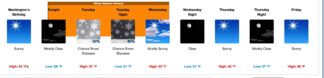
Frazier Park, Pine Mountain, Cuddy Valley, CA and Frazier Mountain Community (Monday, Feb.. 21, 2022 at noon )—Motorists: Be alert.  Winter is not giving up without a fight.  Poppies are starting to carpet hillsides south of the Grapevine, with occasional days tipping into the 60s-70s last week, but Presidents’ Day Monday brought gusty winds and temperatures plummeting below freezing. Snow flurries are likely by Tuesday and Wednesday. MOTORISTS: There is still black ice from the snows of two weeks ago hiding in curving mountain roads covered by shadow. Drive slowly. These areas are just as treacherous, with motorists still losing control and skidding on the ‘S’ curves on Mil Potrero Highway and of some Pine Mountain, Pinon Pines and Lake of the Woods roads.  Here is the National Weather Service forecast for the week:
Monday, —Washington’s Birthday
Sunny, with a temperature falling to around 35 by 5p.m. Northwest wind 10 to 15 mph, with gusts as high as 25 mph.
Monday Night, February 21, 2022
Mostly clear, with a low around 26. Light and variable wind becoming west northwest 5 to 10 mph after midnight. Winds could gust as high as 25 mph.
Tuesday
A 50 percent chance of snow showers. Partly sunny, with a high near 37. West northwest wind 10 to 15 mph, with gusts as high as 30 mph. New snow accumulation of less than one inch possible.
Tuesday Night
A 40 percent chance of snow showers, mainly before 10 p.m.. Mostly cloudy, with a low around 21. West northwest wind 10 to 15 mph, with gusts as high as 30 mph.
Wednesday
Mostly sunny, with a high near 33. North northwest wind 10 to 15 mph.
Wednesday Night
Clear, with a low around 21. North wind around 10 mph, with gusts as high as 15 mph.
Thursday
Sunny, with a high near 43. Northwest wind around 5 mph.
Thursday Night
Mostly clear, with a low around 27. North northwest wind around 5 mph.
Friday
Sunny, with a high near 48. North wind around 5 mph.
Friday Night
Clear, with a low around 32. North wind around 5 mph.
Saturday
Sunny, with a high near 54. East wind around 5 mph.
Saturday Night
Mostly clear, with a low around 36. East southeast wind around 5 mph.
Sunday
Sunny, with a high near 56. North wind around 5 mph.
*****************************************************************************
Frazier Park, CA and Frazier Mountain Community (Friday, Feb. 4, 2022 at 5:30 am.)— Despite chilly 16 degree nights this past week in the Frazier Mountain Communities (and the reports of “snow bombs in the midwest and eastern U.S.), here in our mountain home we are rolling toward spring…slowly. Friday will be a little gusty, but winds will settle down to a mild 10-15 mph through the coming week. Nights will still be cold, but warmer, in the 30s this week, while daytime highs will be in the 50s over the weekend (grab that jacket), then roll toward just tipping into the 60s next week.
Friday
Sunny, with a high near 47. East northeast wind around 10 mph, with gusts as high as 20 mph.
Friday Night
Clear, with a low around 31. East southeast wind 5 to 10 mph, with gusts as high as 15 mph.
Saturday
Sunny, with a high near 53. East northeast wind 5 to 10 mph, with gusts as high as 20 mph.
Saturday Night
Mostly clear, with a low around 35. East wind 5 to 10 mph, with gusts as high as 20 mph.
Sunday
Sunny, with a high near 59. Northeast wind 5 to 10 mph, with gusts as high as 15 mph.
Sunday Night
Clear, with a low around 38. East wind 5 to 10 mph, with gusts as high as 15 mph.
Monday
Sunny, with a high near 60. East wind around 5 mph becoming north northeast in the afternoon.
Monday Night
Clear, with a low around 37. East northeast wind around 5 mph.
Tuesday
Sunny, with a high near 61. Northeast wind around 5 mph, with gusts as high as 15 mph.
Tuesday Night
Clear, with a low around 40. East wind around 5 mph, with gusts as high as 15 mph.
Wednesday
Sunny, with a high near 62. Northeast wind around 5 mph, with gusts as high as 20 mph.
Wednesday Night
Mostly clear, with a low around 40. East wind around 5 mph, with gusts as high as 15 mph.
Thursday
Sunny, with a high near 61. Northeast wind around 10 mph, with gusts as high as 20 mph.
__________________

Frazier Park, CA and Frazier Mountain Community (Sunday, Jan. 23, 2022)— Days will be sunny, with highs in the 50s. Nights in the mid 30’s, but at higher elevations may dip into freezing, so please stay on alert for black ice, especially on curves and bridges. Some gusty winds this weekend, but overall mild.

Sunday

Sunny, with a high near 55. Southeast wind around 5 mph becoming east northeast in the afternoon. Winds could gust as high as 20 mph.
Sunday Night
Clear, with a low around 35. Northwest wind around 5 mph.
Monday
Sunny, with a high near 56. North wind around 5 mph.
Monday Night
Clear, with a low around 34. Northwest wind around 5 mph.
Tuesday
Sunny, with a high near 57. East northeast wind 5 to 10 mph, with gusts as high as 15 mph.
Tuesday Night
Clear, with a low around 37. East southeast wind around 5 mph.
Wednesday
Sunny, with a high near 59. Southeast wind 5 to 10 mph becoming east northeast in the afternoon.
Wednesday Night
Clear, with a low around 38. North northeast wind around 5 mph becoming east southeast in the evening.
Thursday
Sunny, with a high near 59. East wind around 10 mph, with gusts as high as 20 mph.
Thursday Night
Partly cloudy, with a low around 39. East wind around 10 mph, with gusts as high as 20 mph.
Friday
Sunny, with a high near 59. East wind around 10 mph, with gusts as high as 20 mph.

Frazier Park, CA and Frazier Mountain Community (Thursday, Jan. 20, 2022 at noon)— Are you bored with clear roads and sunny skies, temperatures that don’t have you shivering or checking your bank account to see if you can afford to get another tank of propane or turn up the thermostat? Awww. You may just have to get used to temps in the mid 50s, with nights that are chilly, but seldom freezing for another week or so.
Here’s the National Weather Service valentine forecast as we slide toward the end of the month:

Thursday
Sunny, with a high near 58. Southeast wind 5 to 10 mph becoming east northeast in the afternoon.

Thursday night
Clear, with a low around 37. West wind 5 to 10 mph.

Friday
Sunny, with a high near 55. West wind 5 to 15 mph becoming east in the afternoon.
Friday Night
Clear, with a low around 34. North northeast wind 10 to 15 mph.
Saturday
Sunny, with a high near 52. Breezy, with a northeast wind 20 to 25 mph, with gusts as high as 40 mph.
Saturday night
Clear, with a low around 34. East northeast wind around 5 mph becoming west northwest after midnight. Winds could gust as high as 20 mph.

Fazier Park, CA and Frazier Mountain Community (Monday, Jan. 17, 2022 at 9 a.m.)—There is a chance of rain for Monday, but the rest of the week will be mostly sunny, with lows above freezing and highs in the 50s. Please remember that higher elevations in other sections of the Mountain Community may dip into freezing during the night, which could lead to black ice freezing. So be cautious on bridges and curves and other areas that may have daytime melt of snow that is still on the hillsides.

Detailed Forecast

M.L.King Day
A 50 percent chance of showers, mainly after 4pm. Mostly cloudy, with a high near 54. Southeast wind around 5 mph becoming calm in the afternoon. New precipitation amounts of less than a tenth of an inch possible.
Tonight
A 30 percent chance of showers, mainly before 10pm. Mostly cloudy, with a low around 38. Calm wind becoming west around 5 mph after midnight.
Tuesday
Sunny, with a high near 52. Northwest wind around 10 mph.
Tuesday Night
Mostly clear, with a low around 35. West northwest wind 5 to 10 mph.
Wednesday
Sunny, with a high near 55. North wind around 5 mph.
Wednesday Night
Mostly clear, with a low around 36. North wind around 5 mph becoming east after midnight. Winds could gust as high as 15 mph.
Thursday
Sunny, with a high near 58. East northeast wind 5 to 10 mph, with gusts as high as 20 mph.
Thursday Night
Mostly clear, with a low around 38. Northwest wind around 5 mph.
Friday
Sunny, with a high near 60. North northwest wind 5 to 10 mph, with gusts as high as 15 mph.
Friday Night
Mostly clear, with a low around 39. North northeast wind around 10 mph becoming east after midnight. Winds could gust as high as 20 mph.
Saturday
Sunny, with a high near 57. Northeast wind around 10 mph, with gusts as high as 20 mph.
Saturday Night
Mostly clear, with a low around 38. Northeast wind around 10 mph, with gusts as high as 15 mph.
Sunday
Sunny, with a high near 58. Northeast wind around 10 mph, with gusts as high as 20 mph.

This is part of the February 18, 2022 online edition of The Mountain Enterprise.

Have an opinion on this matter? We'd like to hear from you.