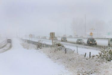
Image 1 of 2
Community Reporter Chuck Noble filed this photo of Interstate 5 traffic moving slowly over The Grapevine Monday afternoon. Lebec Road, at left, is passable.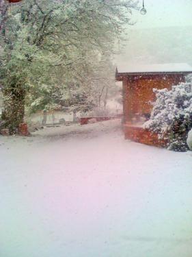
Image 2 of 2
Community Reporter John Delmos sent this snowy scene this afternoon.
UPDATE—FRAZIER PARK, CA / The GRAPEVINE (WEDNESDAY, FEB. 29, 2012 at 9 a.m.)—Schools are open and most roads are clear and passable. Drive carefully, as icy patches on roads, mountain curves and bridges can be treacherous.
UPDATE—FRAZIER PARK, CA / The GRAPEVINE (TUESDAY, FEB. 28, 2012 at 6:30 a.m.)—Traffic is again flowing normally over the Grapevine. Skies are clear. Temperatures are at freezing. Drive carefully, as icy patches on roads can be treacherous.
FRAZIER PARK, CA / The GRAPEVINE (MONDAY, FEB. 27, 2012 at 5:40 p.m.)–Community Reporter Leslie Long reported that CHP is now starting escorts southbound from Grapevine. Northbound and southbound escorts are taking place as weather and resources permit.
FRAZIER PARK, CA / The GRAPEVINE (MONDAY, FEB. 27, 2012 at 3:25 p.m.)–CHP Fort Tejon Office reports that they are starting escorts over The Grapevine (Interstate 5) as snow continues falling from Lebec to Pine Mountain. "We’re going to run some escorts with this group starting at 4:15 to 4:30 and see how it goes," said CHP Officer Robert Shuck. Community reporters have reported seeing escorts already running.
FRAZIER PARK, CA / The GRAPEVINE (MONDAY, FEB. 27, 2012 at 1:30 p.m.)–The Grapevine is now closed in both directions, due to snowfall.
FRAZIER PARK, CA / The GRAPEVINE (MONDAY, FEB. 27, 2012 at 1:06 p.m.)–CHP is escorting traffic over Interstate 5 (The Grapevine), as snow falls across the Mountain Community.
FRAZIER PARK, CA / The GRAPEVINE (MONDAY, FEB. 27, 2012 at 10:40 a.m.)–A light snow is falling in Frazier Park. The Grapevine (Interstate 5) is open. Mil Potrero Highway in to Pine Mountain is open with areas of ice and snow on the roadway. The National Weather Service has forecast a possible one to three inches of snow accumulation for the area, from Monday afternoon through Monday evening.
PINE MOUNTAIN, CA / RIDGE ROUTE / The GRAPEVINE (MONDAY, FEB. 27, 2012 at 8:58 a.m.)–There are still stormclouds passing overhead, but the snow has stopped and patches of blue sky are showing through. Most surface streets are clear, although shadowy mountain roads still have snow. Icy spots are likely. Please drive slowly and with caution.
PINE MOUNTAIN, CA / RIDGE ROUTE / The GRAPEVINE (MONDAY, FEB. 27, 2012 at 7:40 a.m.)–In just 20 minutes a snow of about half an inch has covered the roads of Pine Mountain. The Grapevine is clear and open. No incidents are mentioned by California Highway Patrol over the Grapevine at this time.
Plows are starting to come out in Pine Mountain at the higher elevations. More updates will be posted as news occurs.
At about 6:56 a.m. a city public works truck and a silver sedan private vehicle were reportedly involved in a fatal crash, with the sedan over the side on Lake Hughes Road near Ridge Route Road in Castaic. An L.A. County Coroner has been called and CHP is at the scene.
PINE MOUNTAIN, CA / The GRAPEVINE (MONDAY, FEB. 27, 2012 at 7:15 a.m.)–Storm clouds from the west have just blown into the area and are dropping a light snow at higher elevations. We will post updates as they occur. Roads are clear.
Here’s the National Weather Service forecast for the general area:
Winter Weather Advisory
Hazardous Weather Outlook
Today (Monday): Snow showers likely, mainly before 4pm. Some thunder is also possible. Cloudy, with a high near 35. Breezy, with a west northwest wind 5 to 10 mph increasing to between 20 and 25 mph. Winds could gust as high as 30 mph. Chance of precipitation is 70%. Total daytime snow accumulation of 1 to 3 inches possible.
Tonight: A 50 percent chance of snow showers, mainly before 10pm. Cloudy, then gradually becoming partly cloudy, with a low around 13. Wind chill values as low as -1. Blustery, with a northwest wind 20 to 25 mph decreasing to between 10 and 15 mph. Winds could gust as high as 30 mph. New snow accumulation of less than a half inch possible.
Tuesday: Mostly sunny, with a high near 45. Wind chill values as low as -1 early. Northwest wind between 5 and 10 mph.
Tuesday Night: Partly cloudy, with a low around 21. West wind between 5 and 10 mph, with gusts as high as 15 mph.
Wednesday: Mostly cloudy, with a high near 49. West northwest wind between 10 and 15 mph, with gusts as high as 15 mph.
Wednesday Night: A slight chance of rain and snow showers. Mostly cloudy, with a low around 21. Chance of precipitation is 20%.
Thursday: Partly sunny, with a high near 48.
Thursday Night: Mostly clear, with a low around 24.
Friday: Sunny, with a high near 56.
Friday Night: Mostly clear and blustery, with a low around 27.
Saturday: Sunny and breezy, with a high near 63.
Saturday Night: Mostly clear and blustery, with a low around 27.
Sunday: Sunny, with a high near 63.
This is part of the February 24, 2012 online edition of The Mountain Enterprise.
Have an opinion on this matter? We'd like to hear from you.