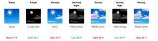
Sunny skies return to the mountain for the weekend and next week. Double click to enlarge this image.
Frazier Park, Lebec, CA (Friday, Feb. 22, 2019 at 6:50 a.m.)—Interstate 5 is open today, Friday, in both directions over the Grapevine. Sunny skies are back in the National Weather Service Forecast for the next five days:
Detailed Forecast
Pine Mountain Club, The I-5 Grapevine, Frazier Park, Lebec, Cuddy Valley, CA (Thursday, Feb. 21, 2019 at 4:25 p.m.)—Multiple accidents on Mil Potrero Highway, including at Voltaire and Woodland, are good reasons to try to stay off the road if you can. In addition, Hudson Ranch Road (often suggested by GPS systems as an alternate to using the Grapevine) is not a great choice. Multiple cars are reported stuck there on the way to 166. The Grapevine is open. See forecast for Thursday evening and Friday below.
Pine Mountain Club, The I-5 Grapevine, Frazier Park, Lebec, Cuddy Valley, CA (Thursday, Feb. 21, 2019 at 2:25 p.m.)—Motorists are beginning to slide and get stuck on Hudson Ranch Road and Mil Potrero Highway. One vehicle is stuck in the middle of the roadway near Woodland Drive. See forecast for Thursday evening and Friday below.
Pine Mountain Club, The I-5 Grapevine, Frazier Park, Lebec, Cuddy Valley, CA (Thursday, Feb. 21, 2019 at 2:05 p.m.)—CHP is now escorting southbound and northbound vehicles over the Grapevine summit. Gorman School has reported that they will have a two-hour delay Friday, Feb. 22. See forecast for Thursday evening and Friday below:
Gorman, the I-5 Grapevine, CA (Thursday, Feb. 21, 2019 )— Once again snow and slick roads stopped traffic on the northbound interstate five today in Gorman. Hundreds of cars were snarled in the traffic jam today. Gorman Post Road was not much better for several hours as Caltrans had several snowplows working the interstate, however they were unable to keep up with the amount of snow. See photos at right and see forecast below:
The National Weather Service forecast at 3 p.m. Thursday:
Pine Mountain Club, The I-5 Grapevine, Frazier Park, Lebec, Cuddy Valley, CA (Thursday, Feb. 21, 2019 at 1:28 p.m.)—CHP is beginning to escort vehicles (300-500 at a time) over the summit southbound from Grapevine Road.
Pine Mountain Club, The I-5 Grapevine, Frazier Park, Lebec, Cuddy Valley, CA (Thursday, Feb. 21, 2019 at 12:10 p.m.)—Motorists are blocked from accessing Interstate 5 using Frazier Mountain Park Road onramps. The northbound onramp at Gorman School School Road is also blocked due to snow conditions. CHP is directing motorists to use Ralph’s Ranch Road south from Frazier Mountain Park Road to reach the I-5 southbound onramp at Gorman School Road.
Pine Mountain Club, The I-5 Grapevine, Frazier Park, Lebec, Cuddy Valley, CA (Thursday, Feb. 21, 2019 at 11:40 a.m.)—Traffic has been stopped at the Grapevine portion of Interstate 5 due to snow sticking to the roadway, causing unsafe driving conditions. Southbound traffic has been stopped in Lebec at Grapevine Road. In Gorman, CHP units are directing northbound traffic to get off of the freeway at the Gorman School Road exit and turn around to drive back south. Fort Tejon CHP had issued the following message at 11:12 a.m.: “We are getting in position to hold all traffic northbound at Gorman and southbound at Grapevine Road for the Grapevine portion of Interstate 5. When Caltrans has made the roadway safe again, we will let traffic continue.”
Pine Mountain Club, The I-5 Grapevine, Frazier Park, Lebec, Cuddy Valley, CA (Thursday, Feb. 21, 2019 at 10:28 a.m.)—Ice is a real danger. Plowing and cindering are slow throughout the mountain while snow is pretty constant. As noted by the PMCPOA clubhouse: “The roads are being plowed but there is ice under the snow (This is both PMC roads and Mil Potrero Hwy).” Roads are not cindered until after snow stops, so be cautious; use chains. Escorts are being run on the Grapevine. The truck stuck on Mt. Pinos Way near the Pharmacy is reported as still there. This may be a good day to stay in if you can.
The Grapevine on I-5 (Thursday, Feb. 21, 2019 at 10:10 a.m.) —Fort Tejon CHP reports moderate snow flurries on NB and SB Grapevine. DRIVE WITH CAUTION. Slow down for the conditions. Stay safe.
The Grapevine on I-5, Lebec, Pine Mountain Club and Frazier Park, CA (Thursday, Feb. 21, 2019 at 8:28 a.m.) —As the sun rose this morning there was a moment of breathtaking beauty as the sky cleared and hills glistened. Then the snow resumed with new intensity. Kern County is plowing and cindering on county roads (Frazier Mountain Park Road and Cuddy Valley Road) but Pine Mountain Club roads are covered with snow. Watch for icy patches in Frazier Park, there are some stuck vehicles.
The Grapevine on I-5, Lebec and Frazier Park, CA (Thursday, Feb. 21, 2019 at 7:25 a.m.) —School is cancelled for ETUSD today. That is Frazier Park School, Frazier Mountain High School and El Tejon School. It is snowing in Pine Mountain Club. Onramp to Grapevine is accessible, CHP says. Ten inches of snow measured at Pine Mountain Club higher elevations.
The Grapevine on I-5, Lebec and Frazier Park, CA (Thursday, Feb. 21, 2019 at 7 a.m.) —Snow has resumed in Pine Mountain Club. There is 4-6 inches of new snow on the ground this morning. Plowing appears slow to get underway in this area.
The Grapevine on I-5, Lebec and Frazier Park, CA (Thursday, Feb. 21, 2019 at 5 a.m.) —The Grapevine is open. On the Grapevine: Motorists are advised to drive cautiously and at low speeds. Caltrans is working to plow and sand Interstate 5 while CHP is assisting to keep I-5 open from Gorman Post Road north and south. Snow at about 3:30 a.m. near Highway 138 was a concern. But snow is at about 1/2 inch currently. Drive with caution. It is cold and will remain cold through the day, with temperatures at freezing level.
Lebec and Frazier Park, CA (Thursday, Feb. 21, 2019 at 4:54 a.m.)—El Tejon Unified School District, including Frazier Mountain High School, El Tejon School and Frazier Park Elementary School will have a two-hour delay this morning. Interim Superintendent Sara Haflich tweeted out the notice as robocalls went out to parents. “We’ll see where we’re at in a bit,” she added. Meanwhile, the National Weather Service said snow showers are anticipated before 10 a.m. Here’s the NWS forecast:
National Weather Service Forecast for Mountain Communities:
Frazier Park, CA (Wednesday, Feb. 20, 2019 at 4 a.m.)— There is a 30% chance of snow after 10 a.m. this morning, but NWS forecasts sunny skies with a high near 40 degrees and 10 mph winds. Tonight, precipitation is 60% likely after 10 p.m., with up to two inches of snow possible. See forecast below
Winter Storm Watch – Wednesday to Thursday
URGENT – WINTER WEATHER MESSAGE
National Weather Service Hanford CA
508 AM PST Tue Feb 19 2019 CAZ095-192115- /O.CON.KHNX.WS.A.0007.190220T2100Z-190222T0000Z/
Kern County Mountains- Including the cities of Tehachapi and Lake Isabella
508 AM PST Tue Feb 19 2019
…WINTER STORM WATCH REMAINS IN EFFECT FROM WEDNESDAY AFTERNOON THROUGH THURSDAY AFTERNOON…
* WHAT…Heavy snow possible. Total snow accumulations of up to 5 inches possible. Winds could gust as high as 35 mph.
* WHERE…Kern County Mountains above 2000 feet.
* WHEN…From Wednesday afternoon through Thursday afternoon.
* ADDITIONAL DETAILS…Snow will likely cause hazardous travel conditions over area passes including Interstate 5 over the Grapevine, Highway 58 over Tehachapi Pass, Highway 178 over Walker Pass and Highway 155 over Greenhorn Summit. Plan on slippery road conditions. The hazardous conditions could impact the morning or evening commute.
PRECAUTIONARY/PREPAREDNESS ACTIONS… A Winter Storm Watch means there is potential for significant snow, sleet or ice accumulations that may impact travel. Continue to monitor the latest forecasts.
FRAZIER PARK, CA (Sunday, Feb. 17, 2019 at 9:50 a.m.)—The National Weather Service has reduced its snow forecast to “1 to 2 inches” today and “1 to 3 inches” tonight. At 7:30 this morning the NWS forecast for today was “3 to 5” inches and for tonight it was “4 to 8” inches.
FRAZIER PARK, CA (Sunday, Feb. 17, 2019 at 7:25 a.m.)—The National Weather Service has forecast three to five inches of snow today PLUS new snow accumulation of four to eight inches tonight.
The detailed forecast is below:
Today
Snow showers. The snow could be heavy at times. High near 36. Breezy, with a northwest wind 20 to 25 mph, with gusts as high as 30 mph. Chance of precipitation is 90%. Total daytime snow accumulation of 3 to 5 inches possible.
Tonight
Snow showers likely, mainly before 10pm. The snow could be heavy at times. Mostly cloudy, with a low around 22. Blustery, with a northwest wind 20 to 25 mph, with gusts as high as 30 mph. Chance of precipitation is 70%. New snow accumulation of 4 to 8 inches possible.
Monday (Washington’s Birthday)
Mostly cloudy, then gradually becoming sunny, with a high near 34. Northwest wind around 15 mph, with gusts as high as 25 mph.
Monday Night
Mostly clear, with a low around 18. Blustery, with a northwest wind 15 to 20 mph, with gusts as high as 30 mph.
Tuesday
Sunny, with a high near 38. North wind around 15 mph, with gusts as high as 20 mph.
Tuesday Night
Mostly clear, with a low around 21. North northwest wind around 10 mph, with gusts as high as 15 mph.
This is part of the February 22, 2019 online edition of The Mountain Enterprise.
Have an opinion on this matter? We'd like to hear from you.