Image 1 of 8
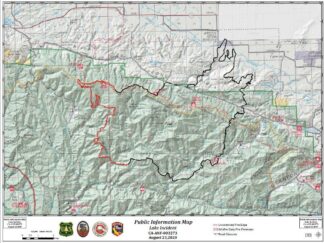
![Lake fire perimeter map as of August 21 at 6 a.m. [This Angeles National Forest fire map is dated August 20 and was the most recent available on the morning of August 21.]](https://mountainenterprise.com/wp-content/uploads/2020_08_21-fire-map-324x243.jpg)
Image 2 of 8
Lake fire perimeter map as of August 21 at 6 a.m. [This Angeles National Forest fire map is dated August 20 and was the most recent available on the morning of August 21.]![Flames of the Lake fire are now being seen from Neenach. [photo by JoAnne Childers Word]](https://mountainenterprise.com/wp-content/uploads/Flames-seen-from-Neenach-web-324x182.jpg)
Image 3 of 8
Flames of the Lake fire are now being seen from Neenach. [photo by JoAnne Childers Word]![The view from Neenach. [photo by JoAnne Childers Word]](https://mountainenterprise.com/wp-content/uploads/Big-flames-from-Neenach-web-324x158.jpg)
Image 4 of 8
The view from Neenach. [photo by JoAnne Childers Word]![The view of the Lake fire from Frazier Park. [photo by the Ryba family]](https://mountainenterprise.com/wp-content/uploads/IMG_1044-web-300x400.jpg)
Image 5 of 8
The view of the Lake fire from Frazier Park. [photo by the Ryba family]![[Photo by JoAnne Childers Word]](https://mountainenterprise.com/wp-content/uploads/Fireforonlinestory_20200812_1703251-324x188.jpg)
Image 6 of 8
[Photo by JoAnne Childers Word]![[photo by USFS Angeles National Forest]](https://mountainenterprise.com/wp-content/uploads/2020_08_12-20-630pm-USFS-web-324x243.jpg)
Image 7 of 8
[photo by USFS Angeles National Forest]![This photo, taken from Los Padres Drive and Elm in Frazier Park, makes it appear that the fire is close to Frazier Park. In fact, the flames are burning on a mountain that is miles south of Highway 138 in Neenach... about 40 miles away from Frazier Park. [photo by Susan Norlund]](https://mountainenterprise.com/wp-content/uploads/0812202038_HDR-web-324x261.jpg)
Image 8 of 8
This photo, taken from Los Padres Drive and Elm in Frazier Park, makes it appear that the fire is close to Frazier Park. In fact, the flames are burning on a mountain that is miles south of Highway 138 in Neenach... about 40 miles away from Frazier Park. [photo by Susan Norlund]
FRAZIER PARK, CA (Wednesday, September 2, 2020 at 8:45 a.m.)—The Lake fire is 95% contained. The size of the fire has not increased in 10 days.
FRAZIER PARK, CA (Sunday August 30, 2020 at 9:30 a.m.)—Firefighters have increased containment of the Lake fire to 87% while holding the size of the blaze to 31,089, according to this morning’s incident command briefing. The fire has been held south of Highway 138 and the towns of Neenach and Fairmont.
FRAZIER PARK, CA (Friday August 28, 2020 at 7:55 a.m.)—The Lake fire incident command report no change in the basic numbers on the fire this morning. The acreage remains at 31,089 and the containment is still 70%. Crews are still working to contain the fire at its northwest on Liebre Mountain and at its southwest above Fish Canyon.
FRAZIER PARK, CA (Thursday August 27, 2020 at 8:45 a.m.)—The Lake fire incident command report no change in the basic numbers on the fire this morning. The acreage remains at 31,089 and the containment is still 70%.
FRAZIER PARK, CA (Wednesday August 26, 2020 at 7:55 a.m.)—The Lake fire continued holding at 31,089 acres over the past day while firefighters increased containment to 70% this morning. This morning’s incident command report follows:
Current Situation: The Lake Fire continued to be less active today with no increase in acreage. Containment is now at 70%. The Lake Fire is burning in 100-year-old fuels consisting of Big Cone Douglas Fir, Oak, and Gray Pine. The fire is holding northeast of Interstate 5 and south of Highway 138 in steep and rugged terrain.
Firefighters were able to hike into the head of Pine Canyon via a trail from Atmore Meadows. Handline has been completed in this section and is ready for tactical firing operations, should conditions allow.
Crews have been mopping up (looking for hotspots within containment lines) in the area of Liebre Mountain and down into lower Pine Canyon. All secondary contingency line has been completed, and suppression repair is underway. Suppression repair activities include pulling brush back over handline and adding water bars to prevent excess erosion on dozer lines. Small amounts of smoke from pockets of vegetation that continue to burn in the fire’s interior continues to be visible.
There have been four reportable injuries to firefighters on this incident.
Weather: Warming and drying after a brief round of tropical moisture will continue to be the theme through the week. Temperatures tonight are forecasted to be 70-75 degrees with humidity hovering around 40-50%. The west to southwest winds will persist tonight at 5-10 mph with gusts up to 15 mph.
Repopulation of Evacuees: This morning, all evacuated residents were permitted to return to their homes. Intermittent power outages and other hazards may still be present in the area. Areas repopulated today, included:
§ South of Highway 138 and CA Aqueduct § East of Old Ridge Route § West of Kings Canyon Road § North of Pine Canyon Road
Please be cautious when driving along recently reopened roads for your safety and the safety of the crews still working in the area.
Roads Reopened Today Included: § Lake Hughes Road from Ridge Route Road to Deeswood Drive § San Francisquito Canyon/Dry Gulch Roads to Lake Hughes Road Areas to Remain Closed: · Lower and Upper Lake Castaic · Lake Castaic Recreation Areas
The Castaic Lake Recreation Area and surrounding areas are being used in support of the fire. The upper and lower lakes and recreation facilities are closed until further notice. Heavy equipment and emergency vehicles are still active along Lake Hughes Road.
Forest Fire Closure/Restrictions: The Angeles National Forest has closed all National Forest System lands within the Lake Fire closure area by Order No. 05-01-20-6. On Saturday, August 1st, the Forest changed its Fire Danger Level from VERY HIGH to EXTREME. Angeles Forest Order No. 05-01-20-05 prohibits all campfires within the Angeles National Forest. No fires of any type including cooking stoves, lanterns, and similar devices which use propane, white gas, or similar fuels are allowed at this time.
Smoke Outlook: Currently, there are no active smoke advisories near the Lake Fire from the South Coast Air Quality Management District.
Cooperating Agencies: CalFire, County of Los Angeles Sheriff’s Department, California Highway Patrol, County of Los Angeles Public Works, County of Los Angeles Animal Care & Control, County of Los Angeles Parks & Recreation, Red Cross, and Southern California Edison.
FRAZIER PARK, CA (Monday August 24, 2020 at 8:30 a.m.)—The Lake fire held at 31,089 acres overnight with no increase in size. Fire crews were able to increase containment to 62%. The fire perimeter map has not been updated since the morning of Aug. 23. The incident command report follows:
Current Situation: Overnight, the Lake Fire was less active with no increase in acreage. Containment now stands at 62%. Two locations that had fire activity overnight were Red Rock Mountain and Cow Spring Canyon. The Lake Fire is burning in 100-year-old fuels consisting of Big Cone Douglas Fir, Oak, and Gray Pine. The fire is holding northeast of Interstate 5 and south of Highway 138 in steep and rugged terrain.
Today’s priority for firefighters is to continue reinforcing containment lines on the southwest edge of the fire. Five crews will also be working in the area of Burrow Canyon to complete that section of containment line. On the northwest flank of the fire, crews plan to use tactical firing operations (applying fire on the ground) as weather conditions allow. On this fire, tactical firing operations are being used to help reduce vegetation (fuel) on the forest floor, by widening already constructed containment lines. However, higher humidity may impact tactical firing operations.
There are many hazards that firefighters encounter when constructing containment lines. One specific hazard on the Lake Fire is the Yucca plant. When burned, the root ball releases from the soil and rolls downhill. These pineapple-sized chunks of burning material can escape containment lines and ignite unburned vegetation below firefighters working in steep terrain. Firefighters must watch out for these hazards to ensure their safety.
There have been two minor reportable injuries to firefighters on the incident.
Weather: With the tropical moisture from remnants of Hurricane Genevieve having passed. Today, we will see a slow warming trend with daytime temperatures forecasted in the upper 80s and low 90s. Relative humidity will be 20-30% and winds will be out of the southwest at 5-15 mph with gusts up to 20 mph.
Repopulation of Evacuees: At 10:00 AMtoday, Monday, August 24th, the previously evacuated residents of Kings Canyon Road east to Shafer Road will be returned to their homes. Residents can only access the area via Elizabeth Lake Road from the east or Lancaster road from the north. There is no access from the west. Intermittent power outages and other hazards may still be present in the area. For safety information on returning home after a wildfire visit: http://bit.ly/ReturningHomeAfterAFire
Evacuations: The following areas remain under evacuation orders; east of Old Ridge Route, west of Kings Canyon Road, north of Pine Canyon Road, Three Points Road south of Highway 138. Unified Incident Commanders continue to evaluate all evacuated areas for the potential to safely repopulate.
Evacuation Point(s): Evacuation points will be opened as needed. If you should need assistance, please call 1-800-Red-Cross (1-800-733-2767).
Road Closures: Three Points Road from Highway 138 to Pine Canyon Road, Old Ridge Route from Highway 138 to Pine Canyon Road, Lake Hughes Road from Ridge Route Road to Deeswood Dive, Pine Canyon Road from Old Ridge Route to Kings Canyon Road, Dry Gulch Road from San Francisquito Canyon Road to Lake Hughes Road.
Additional Closures: The Castaic Lake Recreation Area and surrounding areas are being used in support of the fire. The upper and lower lakes and recreation facilities are closed until further notice.
Forest Fire Closure/Restrictions: The Angeles National Forest has closed all National Forest System lands within the Lake Fire closure area by Order No. 05-01-20-6. On Saturday, August 1st, the Forest changed its Fire Danger Level from VERY HIGH to EXTREME. Angeles Forest Order No. 05-01-20-05 prohibits all campfires within the Angeles National Forest. No fires of any type including cooking stoves, lanterns, and similar devices which use propane, white gas, or similar fuels are allowed at this time.
Animal Care: Antelope Valley Fairgrounds (Large Animals Only) 2551 W Avenue H, Lancaster, CA.
Smoke Outlook: The South Coast Air Quality Management District has extended the air quality advisory for the Lake Fire, affecting San Bernardino and Los Angeles Counties through today. If you smell smoke or see ash due to a wildfire, limit your exposure by remaining indoors with windows and doors closed or seek alternate shelter, in addition to avoiding vigorous physical activity.
Cooperating Agencies: CalFire, County of Los Angeles Sheriff’s Department, California Highway Patrol, County of Los Angeles Public Works, County of Los Angeles Animal Care & Control, County of Los Angeles Parks & Recreation, Red Cross, and Southern California Edison.
FRAZIER PARK, CA (Sunday August 23, 2020 at 9 a.m.)—The Lake fire has grown to 31,089 acres and remains at 52% containment. This morning’s report from the incident command staff follows:
Current Situation: The Lake Fire started in the Angeles National Forest near Lake Hughes and is burning in 100-year-old fuels consisting of Big Cone Douglas Fir, Oak, and Gray Pine. The fire is burning northeast of Interstate 5 and south of Highway 138.
The influence of tropical moisture and higher humidity allowed them to utilize direct attack strategies in the area of Burro Canyon. Hand crews and engines are working on reinforcing and holding containment lines on the southwest edge of the fire. The chance of thunderstorms this afternoon could pose a challenge for firefighters with the potential for lightning strikes, gusty winds, localized flooding and debris flows. Despite winds gusting up to 40 mph during the overnight hours, containment lines have held.
Crews are using tactical firing operations (applying fire on the ground) as conditions allow. Tactical firing operations help reduce vegetation (fuel) on the forest floor, to widen previously constructed containment lines and stop the progress of the fire to the north and west to protect communities. Because the area is so steep and inaccessible, tactical firing operations utilize aerial ignition sources. One of the aerial tools being utilized is the Heli-torch. This is large unit suspended from a helicopter that dispenses ignited fuel over large areas to burn and reduce vegetation on the forest floor.
Firefighters will continue to mop up and look for hot spots on the east flank of the fire, west of Lake Hughes, as this area of the fire line has held for several days.
Weather: Tropical moisture and instability continues to influence the local weather pattern, bringing a 15-20% chance of showers and thunderstorms after 11:00 AM today. A Flash Flood Watch remains in effect for the interior mountains, Cuyama and Antelope Valleys from 12:00 PM until 9:00 PM. Recent burn areas, including the Lake Fire, could experience flooding and debris flows. Cloud cover is expected to increase, moderating today’s high temperatures to the upper 80s and 90s, with humidity ranging around 20-30%. Southwesterly winds will continue, with gusts up to 20 mph in the afternoon.
Repopulation of Evacuees: Residents of the northeast area of the Lake Hughes community were permitted to return to their homes on Friday. Residents can only access the area via Elizabeth Lake Road from the east. There is no access from the west due to the current road closures. Residents returning to their homes will have to show identification. Intermittent power outages and other hazards may still be present in the area. For safety information on returning home after a wildfire visit: bit.ly/repopfacts
Evacuations: The following areas will remain under evacuation orders; South of Highway 138, East of Old Ridge Route, West of Shafer Road, North of Pine Canyon Road / Elizabeth Lake Road, Lake Hughes Road South of Deeswood Drive, and North of Dry Gulch Road. Unified Incident Commanders are evaluating all evacuated areas for the potential to safely repopulate.
Evacuation Point(s): Evacuation points will be opened as needed. If you should need assistance, please call 1-800-Red-Cross (1-800-733-2767).
Road Closures: Three Points Road from Highway 138 to Pine Canyon Road, Old Ridge Route from Highway 138 to Pine Canyon Road, Lake Hughes Road from Ridge Route Road to Deeswood Drive, Pine Canyon Road from Old Ridge Route to Shafer Road, Dry Gulch Road from San Francisquito Canyon Road to Lake Hughes Road.
Additional Closures: The Castaic Lake Recreation Area and surrounding areas are being used in support of the fire. The upper and lower lakes and recreation facilities are closed until further notice.
Forest Fire Closure/Restrictions: The Angeles National Forest has closed all National Forest System lands within the Lake Fire closure area by Order No. 05-01-20-6. Fire danger in the Angeles National Forest has continued to increase. On Saturday, August 1st, the Forest changed its Fire Danger Level from VERY HIGH to EXTREME. The Angeles Forest Order No. 05-01-20-05 prohibits all campfires within the Angeles National Forest. No fires of any type including cooking stoves, lanterns, and similar devices which use propane, white gas, or similar fuels are allowed at this time.
Animal Care: Antelope Valley Fairgrounds (Large Animals Only) 2551 W Avenue H, Lancaster, CA.
Smoke Outlook: The South Coast Air Quality Management District has issued an air quality advisory for the Lake Fire, affecting San Bernardino and Los Angeles Counties. If you smell smoke or see ash due to a wildfire, limit your exposure by remaining indoors with windows and doors closed or seek alternate shelter, in addition to avoiding vigorous physical activity.
Cooperating Agencies: CalFire, County of Los Angeles Sheriff’s Department, California Highway Patrol, County of Los Angeles Public Works, County of Los Angeles Animal Care & Control, County of Los Angeles Parks & Recreation, Red Cross, and Southern California Edison.
FRAZIER PARK, CA (Saturday August 22, 2020 at 5:33 a.m.)—The Lake fire has grown to 30,763 acres and remains at 52% containment. Angeles National Forest has not updated its Lake fire perimeter maps since Thursday morning, Aug. 20. This morning’s report from the incident command staff follows:
Current Situation: The Lake Fire started in the Angeles National Forest near Lake Hughes. The fire is burning in 100-year-old fuels consisting of Big Cone Douglas Fir, Oak and Gray Pine. The fire remains eight miles northeast of Interstate 5 and south of Highway 138.
Firefighters have been successful constructing containment lines around 52% of the fire. They continued to focus their efforts in the northwest and western flanks of the fire in the area of Sawmill Ridge. Hand crews reinforced containment lines on the west edge of the fire in the areas of Bear Canyon and Redrock Canyon. Firefighters continue to be challenged by rugged terrain, high temperatures, critically dry fuels, and drought-stressed trees.
Crews utilized tactical firing operations today (applying fire on the ground) along the northern perimeter of the fire. Tactical firing operations help reduce vegetation (fuel) on the forest floor, to widen previously constructed containment lines and stop the forward progress of the fire to the north.
Firefighters continue to mop up on the east flank of the fire, west of Lake Hughes. The fire line has held for several days in this area.
Weather: An Excessive Heat Warning for dangerously hot conditions along with high temperatures between 95’ and 105’ degrees is in effect until 10 PM this evening for the Santa Clarita, San Fernando and San Gabriel Valleys. Tonight will become partly cloudy, with a low around 71. South-southwest wind is forecast 5 to 15 mph becoming north-northwest in the evening, with gusts as high as 25 mph.
Virtual Public Meeting: A virtual meeting was held this evening at 6:00 PM, to provide a Lake Fire overview and allow the public to ask questions. This virtual meeting was live-streamed on the following social media channels where replays are now available:
– Angeles National Forest Facebook, @AngelesNationalForest – Los Angeles County Fire Department Facebook, @LACoFD – Los Angeles County Fire Department Instagram, @LACountyFD
Repopulation of Evacuees:
Repopulation of the northeast area of the Lake Hughes community occurred this morning. Residents can only access the area from Elizabeth Lake Road from the east. There is no access from the west. Residents returning to their homes will have to show identification. Repopulated residents may experience intermittent power outages. For safety information on returning home after a wildfire visit: bit.ly/repopfacts
Evacuations: The following areas will remain under evacuation orders; East of Old Ridge Route, West of Shafer Road, South of Highway 138, North of Pine Canyon Road / Elizabeth Lake Road, Lake Hughes Road South of Deeswood Drive and North of Dry Gulch Road. Unified Incident Commanders are evaluating all evacuated areas for the potential to safely repopulate.
Evacuation Point(s): Evacuation points will be opened as needed. If you should need assistance, please call 1-800-Red-Cross (1-800-733-2767).
Road Closures: Three Points Road from Highway 138 to Pine Canyon Road, Old Ridge Route from Highway 138 to Pine Canyon Road, Lake Hughes Road from Ridge Route Road to Deeswood Drive, Pine Canyon Road from Old Ridge Route to Lake Hughes Road, Dry Gulch Road from San Francisquito Canyon Road to Lake Hughes Road. Additional Closures: The Castaic Lake Recreation Area and surrounding areas are being used in support of the fire. The upper and lower lakes and recreation facilities are closed until further notice.
Fire Forest Closure/Restrictions: The Angeles National Forest has closed all National Forest System lands within the Lake Fire closure area by Order 05-01-20-6. The fire danger in the Angeles National Forest has continued to increase, and on Saturday, August 1st, the Forest changed its Fire Danger Level from VERY HIGH to EXTREME. The Angeles Forest Order No. 05-01-20-05 prohibits all campfires within the Angeles National Forest. No fires of any type including cooking stoves, lanterns, and similar devices which use propane, white gas, or similar fuels are allowed at this time.
Animal Care: Antelope Valley Fairgrounds (Large Animals Only) 2551 W Avenue H, Lancaster, CA.
Smoke Outlook: The South Coast Air Quality Management District has issued an air quality advisory for the Lake and Ranch 2 Fires for San Bernardino and Los Angeles Counties. If you smell smoke or see ash due to a wildfire, limit your exposure by remaining indoors with windows and doors closed or seek alternate shelter, in addition to avoiding vigorous physical activity.
Cooperating Agencies: County of Los Angeles Sheriff’s Department, California Highway Patrol, County of Los Angeles Public Works, County of Los Angeles Animal Care & Control, County of Los Angeles Parks & Recreation, Red Cross, and Southern California Edison.
FRAZIER PARK, CA (Friday August 21, 2020 at 7:35 a.m.)—The Lake fire is now 28,912 acres and is 52% contained. Twelve structures have been destroyed and six damaged. One firefighter suffered a minor injury. The incident command team’s report follows:
Current Situation: The west flank of the Lake Fire was active today in the areas of Atmore Meadows and Burnt Peak Canyon. Dozers and hand crews made good progress constructing containment lines on the west edge of the fire in the areas of Burro Canyon and Cow Spring Canyon. Firefighters continue to be challenged by rugged terrain, high temperatures, critically dry fuels, and drought-stressed trees.
Crews are using tactical firing operations to help establish containment lines as conditions allow. This is an effective tool to reduce vegetation (fuel) to establish and reinforce containment lines.
Firefighters continue to mop up on the east flank of the fire, west of Lake Hughes. The fire line has held for several days in this area. Unified commanders are evaluating all evacuated areas for the potential to safely repopulate. Mandatory evacuations remain in place.
The fire started in the Angeles National Forest near Lake Hughes. It is moving north and west burning in 100-year-old fuels consisting of Big Cone Douglas Fir, Oak and Gray Pine. The fire remains eight miles northeast of Interstate 5 and south of Highway 138.
There has been one minor reportable injury to a firefighter.
Virtual Public Meeting: There is a planned virtual public meeting tomorrow evening, August 21st at 6:00 PM. This virtual meeting will be live-streamed on:
Angeles National Forest Facebook, @AngelesNationalForest
Los Angeles County Fire Department Facebook, @LACoFD
Los Angeles County Fire Department Instagram, @LACountyFD
Assigned Resources: Engines: 188 Hand Crews: 30 Dozers: 31 Masticators: 4 Water Tenders: 22 Helicopter: 13 Total Personnel: 1,843; Fixed wing Air Tankers are available on request.
Weather: An excessive heat warning for dangerously hot conditions along with high temperatures between 98’ and 110’ degrees is in effect until 9 p.m. this evening for the Santa Clarita, San Fernando and San Gabriel Valleys. Winds are forecasted out of the west and northwest at 10-15 mph with gusts up to 20 mph at the higher elevations, becoming 5-10 mph with gusts up to 15 during the overnight hours.
Evacuations: Lake Hughes Road west of Pine Canyon and north of Dry Gulch Road. East of Ridge Route Road. West of Lake Hughes Road and Fire Station 78. North of Pine Canyon and Lake Hughes. Road. South of SR-138.
Evacuation Point(s): Evacuation points will be opened as needed. If you should need assistance, please call 1-800-Red-Cross (1-800-733-2767)
Road Closures: Three Points Road from Hwy 138 to Pine Canyon, Old Ridge Route from Hwy 138 to Pine Canyon Road, Lake Hughes Road from Ridge Route Road to Pine Canyon Road, Pine Canyon Road from Ridge Route Road to Lake Hughes Road, Dry Gulch Road/San Francisquito Mtwy from San Francisquito Canyon Road to Lake Hughes Road.
Additional Closures: The Castaic Lake Recreation Area and surrounding areas are being used in support of fire operations. Both upper and lower lakes along with all recreation facilities are closed until further notice.
Fire Forest Closure/Restrictions: The Angeles National Forest has closed all National Forest System lands within the Lake Fire closure area by Order 05-01-20-6. The fire danger in the Angeles National Forest has continued to increase, and on Saturday, August 1st, the Forest changed its Fire Danger Level from VERY HIGH to EXTREME. The Angeles Forest Order No. 05-01-20-05 prohibits all campfires within the Angeles National Forest. The Angeles uses a 6 Level Fire Danger Rating System to determine fire restrictions which it adjusts throughout the year. No fires of any type including cooking stoves, lanterns, and similar devices which use propane, white gas, or similar fuels are allowed at this time.
FRAZIER PARK, CA (Thursday August 20, 2020 at 7:55 a.m.)—The Lake fire is at 27,041 acres with 48% containment, according to Angeles National Forest officials.
FRAZIER PARK, CA (Wednesday August 19, 2020 at 7:30 a.m.)—The Lake fire has consumed 26,000 acres and is 38% contained.
The Lake Fire was active overnight where the fire jumped a containment line southwest of Atmore Meadows. Night flying helicopters performed water drops to slow the spread as the fire burned in steep and inaccessible terrain. Firefighters continue to be challenged with high temperatures, critically dry fuels and drought stressed trees. Pyrocumulus clouds are expected to form again today in the afternoon with the potential for dry lightning strikes.
The Lake Fire is currently 25,948 acres with 38% containment. 4,570 structures remain threatened and mandatory evacuations remain in place. The fire is burning on the Angeles National Forest near Lake Hughes and moving northwest towards 100-year-old fuels consisting of Big Cone Douglas Fir, Oak and Gray pine. The Lake Fire remains over eight miles to the northeast of Interstate 5 and south of Highway 138. Firefighters are facing steep and rugged terrain, high temperatures, critically dry fuels and drought stressed trees.
The Lake Fire started on August 12, 2020 and has burned for 8 days. Cause of fire is unknown. There has been one reportable injury to date. The east flank of the fire, just west of Lake Hughes has held for several days. Some of the areas in denser vegetation require extensive mop up. The west flank in the area of Sawmill Mountain, Burnt Peak and Little Burnt Peak is presenting the most challenging fire behavior. Containment along Pine Mountain Road will continue to be threatened by spot fires. Long range spotting; a behavior of fire where sparks or embers are carried by the wind causing new fires outside the perimeter. This continues to be a challenge for our firefighters.
Assigned Resources:
Engines: 213 Hand Crews: 28 Dozers: 39 Water Tenders: 22 Helicopter: 13 Total Personnel: 1,904; Fixed wing Air Tankers are available on request.
PUBLIC MEETING: A Lake Fire Virtual Public Meeting was held Monday evening, and was streamed on the Angeles National Forest Facebook Page, the Los Angeles County Fire Department Facebook @LACoFD and Instagram @LACountyFD. The replay of the live stream can be seen on those channels where the public had the opportunity to ask questions about the fire.
The Angeles National Forest, LA County Fire, LA County Sheriffs Dept., California Highway Patrol and many other cooperating agencies are working together to battle this fire. The Lake Fire Incident Command Post is located in the Castaic Lake Recreation Area. Castaic Lake, both upper and lower lakes, are currently closed to public access. Castaic Lake will remain closed until further notice. Fire personnel are using the lake and surrounding areas as a basecamp for the Lake Fire near Lake Hughes.
(Above) – A Bombardier “Super-Scooper” CL-415, Tail # N386AC, Scoops water from the lake while working the Lake Fire on the Angeles National Forest.
SMOKE OUTLOOK
Overnight, winds from the north and northwest may push smoke into the Santa Clarita Area, and other parts of the Angeles National Forest. In any area impacted by smoke, if you smell smoke or see ash due to a wildfire, limit your exposure by remaining indoors with windows and doors closed or seeking alternate shelter, and avoiding vigorous physical activity. For more tips on protecting yourself during a wildfire, see South Coast AQMD’s Wildfire Smoke & Ash Health & Safety Tips page: http://www.aqmd.gov/wildfire-health-info-smoke-tips
2020_08_15-17.09.14.256-CDT.jpeg
(Above) Pyrocumulus Clouds form above the Lake Fire
WEATHER: An excessive heat warning, dangerously hot conditions along with high temperatures between 98’ and 110’ degrees is in effect until 9 p.m. Thursday for the Santa Clarita, San Fernando and San Gabriel Valleys. Very hot and critically dry conditions will remain again today as high pressure is anchored over the region. Overnight temperatures will be very warm with lows forecasted into the 70’s.
EVACUATIONS: Lake Hughes Road west of Pine Canyon and north of Dry Gulch Road. east of Ridge Route Road west of Lake Hughes Road and Fire Station 78 north of Pine Canyon and Lake Hughes Road south of SR-138.
EVACUATION POINT(S): Evacuation points will be opened as needed. If you should need assistance, please call 1-800-Red-Cross (1-800-733-2767)
ROAD CLOSURES: 3 Points Road from Hwy 138 to Pine Canyon Road, Old Ridge Route from Hwy 138 to Pine Canyon Road, Pine Canyon Road from Ridge Route Road to Lake Hughes Road.
ANIMAL CARE: Antelope Valley Fairgrounds (Large Animals Only) 2551 W Avenue H, Lancaster, CA 93536
FRAZIER PARK, CA (Tuesday August 18, 2020 at 7:45 a.m.)—The Lake fire has burned 21,115 acres and is 38% contained, according to Angeles National Forest officials. Twelve homes have been destroyed.
The Lake Fire is currently 21,115 acres with 38% containment and 4,570 structures remain threatened. Mandatory evacuations are in place. The fire is burning on the Angeles National Forest near Lake Hughes and moving northwest towards 100-year-old fuels consisting of Big Cone Douglas Fir, Oak and Gray pine. The Lake Fire remains over eight miles to the northeast of Interstate 5 and south of Highway 138. Firefighters are facing steep and rugged terrain, high temperatures, critically dry fuels and drought stressed trees.
The Lake Fire started of unknown cause on August 12, 2020 and has burned for 6 days. There has been one reportable injury to date. The right flank of the fire, just west of Lake Hughes has held for several days. Some of the areas in denser vegetation require extensive mop up.The left flank in the area of Sawmill Mountain, Burnt Peak and Little Burnt Peak is presenting the most challenging fire behavior. Containment along Pine Mountain Road will continue to be threatened by spot fires. Crews will watch for fire whirls, or fire devils, a spinning vortex column of ascending hot air and gases rising from a fire.
Assigned Resources: Engines: 234 Hand Crews: 28 Dozers: 42 Water Tenders: 26 Helicopter: 13 Total Personnel: 1,983; Fixed wing Air Tankers are available on request.
PUBLIC MEETING: A video of the Lake Fire Virtual Public Meeting is available on the Angeles National Forest Facebook Page. This was live-streamed at 6 PM on the @AngelesNationalForest as well as the Los Angeles County Fire Department Facebook @LACoFD and Instagram @LACountyFD.
The Angeles National Forest, LA County Fire, LA County Sheriffs Dept., California Highway Patrol and many other cooperating agencies are working together to battle this fire. The Lake Fire Incident Command Post is located in the Castaic Lake Recreation Area. Castaic Lake, both upper and lower lakes, are currently closed to public access. Castaic Lake will remain closed until further notice. Fire personnel are using the lake and surrounding areas as a basecamp for the Lake Fire near Lake Hughes.
WEATHER: ….AN EXCESSIVE HEAT WARNING REMAINS IN EFFECT UNTIL 9 PM THURSDAY…
Very hot conditions will continue through the week with very warm nights, especially for valley and interior areas. Temperatures will cool only slightly later in the week and will remain above normal through early next week. There is a slight chance of thunderstorms through Wednesday mostly over the mountains and the Antelope Valley.
SMOKE OUTLOOK
Overnight, winds from the north and northwest may push smoke into the Santa Clarita Area, and other parts of the Angeles National Forest. In any area impacted by smoke, if you smell smoke or see ash due to a wildfire, limit your exposure by remaining indoors with windows and doors closed or seeking alternate shelter, and avoiding vigorous physical activity. For more tips on protecting yourself during a wildfire, see South Coast AQMD’s Wildfire Smoke & Ash Health & Safety Tips page: http://www.aqmd.gov/wildfire-health-info-smoke-tips
EVACUATION ORDERS remain in effect for the Lake Hughes and surrounding area. Evacuating the forest fire area early also helps firefighters keep roads clear of congestion, and lets them move more freely to do their job. If you are advised to leave, don’t hesitate! Please sign up to the Alert LA County notification system to receive early warnings about emergencies in your area.
Lake Hughes Road West of Pine Canyon and North of Dry Gulch Road.
East of Ridge Route Road West of Lake Hughes Road and Fire Station 78
North of Pine Canyon and Lake Hughes Road South of SR-138.
Evacuation Point(s): Highland High School – 39055 25th Street West Palmdale, CA 93551 was closed at noon today, but will reopen if necessary. Those in need can call 1-800-Red-Cross (1-800-733-27677)
Clients and small animals can relocate to the evacuation point where individual needs will be assessed by Red Cross Personnel. Clients must remain in vehicles and abide by Los Angeles County Health Orders.
ROAD CLOSURES: 3 Points Road from Hwy 138 to Pine Canyon Old Ridge Route from Hwy 138 to Pine Canyon Pine Canyon Road from Ridge Route Road to Lake Hughes Road.
ANIMAL CARE: Large Animals only, AV Fairgrounds, 2551 W Avenue H, Lancaster, CA 93536
FRAZIER PARK, CA (Monday August 17, 2020 at 7:55 a.m.)—The Lake fire is now 18,526 acres in size with 31% containment. A public meeting is scheduled for tonight at 6 p.m. at the Antelope Valley Fairgrounds on the north side of the H.W. Hunter Pavilion near the Grandstand Arena, 2551 W Avenue H, in Lancaster. See details and attendance requirements below:
PUBLIC MEETING NOTICE: The Unified Command for the Lake Fire will hold a public meeting at 6pm on Monday, August 17, 2020 to provide a fire operations overview.
The public meeting will be held at the Antelope Valley Fairgrounds on the north side of the H.W. Hunter Pavilion near the Grandstand Arena, 2551 W Avenue H, in Lancaster. Those attending should park in the main parking lot and will be required to wear a face covering and follow social distancing protocols per the Los Angeles County Public Health Order.
A face covering will be provided, if needed.
The meeting will also be live streamed on the Angeles National Forest Facebook @AngelesNationalForest as well as the Los Angeles County Fire Department Facebook @LACoFD and Instagram @LACountyFD.
The Lake Fire is currently 18,526 acres and is 31% contained. Structures are threatened and mandatory evacuations are in place. Fire remains over 8 miles northeast of Interstate 5 and south of Highway 138.
1,894 personnel are assigned to the fire, including:
30 Hand Crews
25 Dozers
194 Engines
23 Water Tenders
12 Helicopters
Fixed wing Air Tankers are available on request.
The Lake Fire incident command post is located in the Castaic Lake Recreation Area. Castaic Lake, both upper and lower lakes, are currently closed to public access. Lake will remain closed until further notice. Fire personnel are using the lake and surrounding areas as a basecamp for the Lake Fire in Lake Hughes.
The Angeles National Forest, LA County and other cooperating agencies are working together to battle this fire. There are no injuries to firefighters at this time.
2020_08_15-15.10.28.175-CDT.jpeg2020_08_15-15.21.47.330-CDT.jpeg2020_08_15-15.10.56.917-CDT.jpeg
Evacuation orders remain in effect for the Lake Hughes and surrounding areas…
WEATHER: An excessive heat warning remains in effect through August 20, 9 PM. Daytime Temperatures will range from 108 to 111 degrees. A slight chance of thunderstorms each afternoon will continue through Wednesday.
SMOKE OUTLOOK The South Coast Air Quality Management District has issued an air quality advisory for the Lake and Ranch2 Fires for San Bernardino and Las Angeles Counties. For detailed information on air quality advisories, see the additional links below.
Smoke from the Lake and Ranch2 Fires will continue impact communities surrounding and down drainage of the fires from Mojave to the South Coast. Expect Moderate to USG air quality in Santa Clarita and Los Angeles, with periods of air quality improvement mid to late afternoon as fire activity increases and south southwest winds push the smoke northeast. Communities northeast of the fires may see poor air quality this afternoon depending on fire activity. Smoke will settle back into the communities down drainage late this evening and into Monday morning resulting in poor air quality in the Moderate to USG ranges. Residents north in Lancaster and south in Azusa and Glendora, may see periods of air quality in the Unhealthy range.
2020_08_15-17.09.14.256-CDT.jpeg
ROAD CLOSURES REMAIN IN EFFECT
San Francisquito Canyon Road has been reopened
ROAD CLOSURES:
Three Points Rd. from Hwy 138 to Pine Canyon Rd.
Old Ridge Route Rd. from Hwy 138 to Pine Canyon Rd.
Lake Hughes Road from Ridge Route Rd. to Pine Canyon Rd.
Dry Gulch Rd. from San Francisquito Canyon Rd. to Lake Hughes Rd.
EVACUATION ORDERS remain in effect for the Lake Hughes and surrounding area.
Lake Hughes Road West of Pine Canyon and North of Dry Gulch Rd.
East of Ridge Route Road
West of Lake Hughes Road and Fire Station 78
North of Pine Canyon and Lake Hughes Road
South of SR-138
EVACUATION SHELTERS
Red Cross: 213-347-4775 www.redcross.org/la
Highland High School
39055 25th St. West Palmdale, CA 93551
The Castaic Sports Complex Evacuation Center has been closed.
·Clients and small animals can relocate to evacuation points where individual needs will be assessed by Red Cross Personnel. Clients must remain in vehicles and abide by Los Angeles County Health Orders.
ANIMAL CARE
Large Animals only, AV Fairgrounds, 2551 W Avenue H, Lancaster, CA 93536
FRAZIER PARK, CA (Sunday August 16, 2020 at 7:05 a.m.)—The Lake fire has burned 17,862 acres and remains 12% contained. Twelve structures have been destroyed. No injuries to firefighters have been reported.
ANGELES NATIONAL FOREST REPORT: Improved infrared mapping of the fire perimeter revealed a decrease in acreage burned. Structures are threatened and mandatory evacuations are in place. Currently, 21 Hand Crews: 24 Dozers: 165 Engines: 23 Water Tenders: 13 Helicopters: for a total 1,311 personnel are engage at the fire.
The Lake Fire incident command post is located in the Castaic Lake Recreation Area. Castaic Lake, both upper and lower lakes, are currently closed to public access. Lake will remain closed until further notice. Fire Personnel are using the lake and surrounding areas as a basecamp for the Lake Fire in Lake Hughes.
The Angeles National Forest, LA County and other cooperating agencies are working together to battle this fire. There are no injuries to firefighters at this time.
Poor air quality in and around the area of the fire will affect the public and first responders.
California Incident Management Team 5, a type 1 incident management team has assumed command of the Lake Fire as of 6:00 a.m. August 14, 2020. Poor overnight humidity recovery allowed for the fire to remain active moving into drainages with downslope winds and critically dry fuels. 12 structures have been destroyed. Damage assessment teams are continuing their assessment of the communities impacted by the Lake Fire. There are no injuries to firefighters at this time.
The fire was first reported on August 12th at 3:38 P.M. and is located near Lake Hughes Road just north of Warm Springs.
2020_08_15-15.10.28.175-CDT.jpeg2020_08_15-15.21.47.330-CDT.jpeg2020_08_15-15.10.56.917-CDT.jpeg
Evacuation orders remain in effect for the Lake Hughes and surrounding areas…
EXCESSIVE HEAT WARNING IN EFFECT through Monday at 9:00 p.m.
WEATHER
Another day of dangerous heat as a strong high pressure grips much of the west with temperatures soar into the triple digits. In addition to the heat, dry conditions will prevail over the fire.
2020_08_15-17.09.14.256-CDT.jpeg
ROAD CLOSURES REMAIN IN EFFECT
San Francisquito Canyon Road from Stater Lane to Spunky Canyon
3 Points Road from Hwy 138 to Pine Canyon
Old Ridge Route from Hwy 138 to Pine Canyon
Lake Hughes Road from Ridge Route Road to Pine Canyon
EVACUATION ORDERS remain in effect for the Lake Hughes and surrounding area.
Lake Hughes Road West of Pine Canyon and North of Dry Gulch Rd.
East of Ridge Route Road
West of Lake Hughes Road and Fire Station 78
North of Pine Canyon and Lake Hughes Road
South of SR-138
EVACUATION SHELTERS
Red Cross: 213-347-4775 www.redcross.org/la
Highland High School
39055 25th St. West Palmdale, CA 93551
The Castaic Sports Complex Evacuation Center has been closed.
·Clients and small animals can relocate to evacuation points where individual needs will be assessed by Red Cross Personnel. Clients must remain in vehicles and abide by Los Angeles County Health Orders.
ANIMAL CARE
Castaic Animal Care Center 31044 Charlie Canyon Road Castaic, CA 91384
Large Animals only, AV Fairgrounds, 2551 W Avenue H, Lancaster, CA 93536
FRAZIER PARK, CA (Saturday August 15, 2020 at 7:45 a.m.)—The Lake fire is now 14,714 acres in size and is still 12% contained, according to Angeles National Forest officials from their morning briefing. Six structures have been destroyed. No injuries to firefighters have been reported.
FRAZIER PARK, CA (Friday August 14, 2020 at 12:30 p.m.)—The Lake fire has grown to 11,637 acres and is 12% contained, according to Angeles National Forest officials. Five structures have been destroyed and no injuries to firefighters had been reported by noon today.
MANDATORY EVACUATIONS are as follows:
Lake Hughes Road West of Pine Canyon and North of Dry Gulch Rd.
East of Ridge Route Road
West of Lake Hughes Road and Fire Station 78
North of Pine Canyon and Lake Hughes Road
South of SR-138
EVACUATION SHELTERS
Red Cross: 213-347-4775 www.redcross.org/la
Highland High School
39055 25th St. West Palmdale, CA 93551
Castaic Sports Complex
31230 Castaic Rd. Castaic, CA 91384
·Clients and small animals can relocate to evacuation points where individual needs will be assessed by Red Cross Personnel. Clients must remain in vehicles and abide by Los Angeles County Health Orders.
FRAZIER PARK, CA (Thursday August 13, 2020 at 11 a.m.)—The north edge of the Lake fire is now 4.5 miles south of Highway 138 and 210th Street West. Angeles National Forest officials are estimating that containment of the fire will take until approximately Wednesday, Sept. 2. Over 500 fire fighters from the Angeles National Forest, LA County and other cooperating agencies are working together to battle this fire.
FRAZIER PARK, CA (Thursday August 13, 2020 at 8:58 a.m.)—The Lake fire is now 10,500 acres with zero containment. USFS assessment of projected incident activity is: “Fire will continue to grow and threaten the surrounding communities of Lake Hughes, Leona Valley, Lake Elizabeth, Pine Canyon, Quail Lake, Three Points, Historic Ridge Route and Inventoried Roadless Areas. Spotting and aggressive fire behavior will continue.”
Northwest of Lake Hughes Road and Lake Elizabeth Road
West Trail Mtn View Road in Lake Hughes Community
From there, everything south of Hwy 138, all the way west to Old Ridge Route, including Pine Canyon community
Evacuation Shelter
Highland High School Palmdale
39055 25th St. West Palmdale
Large Animals Shelter
Antelope Valley Fairgrounds
Castaic Fairgrounds
FRAZIER PARK, CA (Wednesday August 12, 2020 at 8:33 p.m.)—Mandatory evacuations are in place for the area of Lake Hughes Rd as follows:
Northwest of Lake Hughes Road and Lake Elizabeth Road
West Trail Mtn View Road in Lake Hughes Community
From there, everything south of Hwy 138, all the way west to Old Ridge Route, including Pine Canyon community
Evacuation Shelter
Highland High School Palmdale
39055 25th St. West Palmdale
Large Animals Shelter
Antelope Valley Fairgrounds
Castaic Fairgrounds
FRAZIER PARK, CA (Wednesday August 12, 2020 at 7:40 p.m.)—Mandatory evacuations are in place for the area of Lake Hughes Rd west of Pine Cyn Rd and south of Dry Gulch Rd.
Evacuation Shelter
Highland High School Palmdale
39055 25th St. West Palmdale
FRAZIER PARK, CA (Wednesday August 12, 2020 at 7:30 p.m.)— Flames are now being seen from Neenach. See the photo sent by JoAnne Childers Word.
FRAZIER PARK, CA (Wednesday August 12, 2020 at 6:41 p.m.)— The Lake fire is now reported to be 10,000 acres with zero containment.
FRAZIER PARK, CA (Wednesday August 12, 2020 at 6:33 p.m.)— The Lake fire has grown to more than 6,000 acres with zero containment. The fire is located about 10 miles south of Highway 138 and the Neenach area.
FRAZIER PARK, CA (Wednesday August 12, 2020 at 5:13 p.m.)— A fast moving wildfire started at about 3:40 p.m., and quickly reached 50 acres in size. Within 45 minutes it had grown to 400 acres. “The fire is burning directly south of us near Pine Canyon Rd and Lake Hughes Rd. We are at 235th Street West in Neenach,” JoAnne Childers Word told The Mountain Enterprise at about 5 p.m. “Were getting ready to evacuate,” she said.
This is part of the September 4, 2020 online edition of The Mountain Enterprise.
Have an opinion on this matter? We'd like to hear from you.