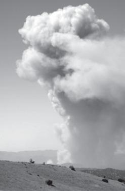
Esther Pereira took this photo Friday, Aug. 24 while driving out on Cerro Noroeste Road. She and husband Walter Pereira saw a sudden ?huge mushroom cloud? of smoke and wondered what had happened. ?I am sure that we were looking at the area around Hwy 33 and Lockwood Valley Road. It was awesome,? Esther said. Firefighters were still creating backfires to burn out fuel and halt the Zaca fire?s advance.
On September 2 the Zaca fire in the Los Padres Forest northeast of Santa Barbara was finally officially proclaimed 100 percent contained. It started when ranchers were using spark-emitting tools to fix a water pipe on July 4.
The wildfire consumed 240,207 acres, making it the second largest burn in modern California history. The Cedar fire in San Diego County in October, 2003 took 15 lives and burned 273,246 acres. There were 38 injuries among the 3,000 firefighters who were battling the Zaca blaze. Although there were several evacuations and forest closures, only a single outbuilding was burned. The fire has cost $117.4 million so far.
Aircraft using infrared photography will assist in identifying remaining hot spots within the interior of the fire. Continuing hot and dry weather will increase the potential for fire activity in unburned vegetation within the fire’s perimeter.
A fire is considered contained when a line has been completed around the fire, and any associated spot fires, which can reasonably be expected to stop the fire’s spread. A fire is considered "controlled" when the containment lines can reasonably be expected to hold under the foreseeable conditions.
The Zaca fire is not expected to be controlled for at least several more weeks, USFS spokesperson Joe Pasinato said Tuesday, Sept. 4.
Firefighters will maintain a 500-foot wide perimeter in which all residual fire will be extinguished. Interior islands of unburned fuel will continue to put up visible columns of smoke until the area receives rain or prolonged higher humidity. Aircraft using infrared photography will assist in monitoring the fire.
Heavy equipment is still present in many areas, rehabilitating roads and dozer lines, while hand crews assist with fire line rehabilitation and chipping of cut brush and other vegetation. These efforts will assist in restoring public lands for use, and help prevent erosion and further damage.
Rehabilitation of fire control lines is expected to be completed by September 7.
A Burned Area Emergency Response (BAER) team continues assessing the fire’s impacts to the national forest and will recommend measures to prevent additional damage to roads, trails and drainages.
Due to continuing hazards in the fire area, the Zaca Fire Area Closure in Los Padres National Forest remains in effect. The closure extends roughly from Highway 166 to Highway 33. Highway 33 between Wheeler Gorge and Quatal Canyon Road is now open to through-traffic.
Mt. Pinos recreation areas are open. Reyes Peak Road and the Boulder Canyon hiking trail which were both used as containment lines along with everything west of Highway 33 will remain closed.
The public is reminded to use extreme caution in and around the fire area especially in the area of East Camino Cielo between Highway 154 and Gibraltar Road, as fire crews continue to work in this area.
Detailed information regarding the closure is available at www.inciweb.org or at offices of the Los Padres National Forest. Chuchupate Ranger Station in Lockwood Valley can be reached at (661) 245-4903.
Highways, Forest Roads and Area Closures:
- Happy Canyon Road is closed at the Los Padres National Forest boundary.
- Figueroa Mountain Road is closed at the Los Padres National Forest boundary.
- East Camino Cielo Road is open between Hwy 154 and Gibraltar Road.
- East Camino Cielo is closed east of Gibraltar Road.
- Paradise Road is open from Highway 154 to the first crossing of the Santa Ynez River. All U.S. Forest Service recreation facilities along Paradise Road (with the exception of First Crossing Day Use Area) and Rancho Oso are open. Santa Ynez River Road and all recreation facilities past the first crossing of the Santa Ynez River are closed.
This is part of the September 07, 2007 online edition of The Mountain Enterprise.
Have an opinion on this matter? We'd like to hear from you.